Moving forward into the future of digitizing our cultural heritage, OML’s Digital Imaging Center is engaged in an innovative project to three-dimensionally image the library’s rare globe collection, the second-largest of its kind in a U.S. public institution. Generous grants from the National Endowment for the Humanities and the Friends of the Osher Map Library support the conservation, and subsequent 3D imaging, of the collection's most threatened or valuable items. Digitization will make it possible for students and members of the public to manipulate and examine the rare globes online, preventing potential handling damage to these delicate objects. A digital undertaking such as this is no small task, considering that full-rounded 3D imaging by cultural institutions is still at its infant stage.
The commercial company, Ortery, provided the equipment and software used to three-dimensionally image the globes. Ortery initially designed its product line with e-commerce in mind, and its technology has been used by companies such as Disney, Mattel, and Converse to provide a 3D view of their online merchandise. Ortery's products have also been used by academic and field-science institutions, providing equipment and software for National Geographic, the Smithsonian, and NASA.
Ortery’s technology enables the photographer to capture an object from almost every angle, building a three-dimensional digital model. OML uses the PhotoCapture 360M turntable, which rotates an item placed on it up to 24 increments per revolution. Synchronized with the turntable is the 3D PhotoArm, which sweeps a camera over the object at each position on the turntable, going from the side to the top of the item. If the object can be can be inverted (as the ball of a globe without its furniture can), then its underside can be similarly imaged for complete coverage. Depending on the size and form of the object, between 216 and 900 images will be created during this image capturing process, automated by Ortery’s software, PhotoCapture 360 Creator. The images are then combined with Ortery’s TruView image-combination software to create the interactive file that enables the viewer to manipulate and examine the object in all of its possible angles.
Imaging complex objects like globes can be quite challenging. The complicated construction of a globe makes it difficult to capture all of its numerous fine details. To thoroughly acquaint ourselves with the imaging equipment, we practiced with modern globes while the first batch of rare globes was being conserved. This learning process revealed three major challenges: lighting, color accuracy, and consistent depth-of-field focus.
These three factors, when adjusted and corrected, will provide consistent lighting across the object. The consistent lighting will have no or minimal hotspots on the globe, which will enable the clarity in the image. It will ensure that the digital image colorfully accurate as much as possible to the original object. And to provide as much focus and sharpness as possible to a spherical object, which is often difficult to achieve.
The post-production work of the images is particularly time consuming process, yet necessary for presenting the images to the general public. Each image must undergo the process of color and tonal correction, and background adjustments. Some of this work can be minimized during the capturing process where parts of this can be automated, however automation can lead to color and tonal inaccuracies. The tedious process of examining each image ensures that the color and tonal accuracies are in compliance to the FADGI and Metamorfoze standards.
To display the digitized globes at https://oshermapsuat.wpengine.com, OML has decided to present all the results of this imaging process. The default display (click on the above image) uses Zoomify to display all of the high-resolution "flat" images taken of each globe. Viewers can examine each high-resolution image and, should they wish, request images of particular portions of the globe. From the default display, clicking on the 3D icon launches the 3D animation. The globe can be rotated a full 360° by clicking on the image, holding, and dragging away from the area you want to view. For example, click and pull the globe downward to see the top. The scroll wheel of the mouse can be used to zoom in and out. Both Zoomify and 3D animation are coded in HTML5 so that they work on all types of computers and mobile devices.
Click here to go directly to the interactive 3D globe.

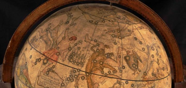
Globo Celeste by Giovanni Maria Cassini, 1792
This particular digital view constitutes a 'before' documentation of an un-conserved globe, the 1792 Globo Celeste by Giovanni Maria Cassini. Because it is yet to be conserved, it has been imaged only in its furniture. Once restored globes are received from the conservator, globe imaging will further entail also imaging both the globe balls and the furniture by themselves, adding two more sets of flat images and 3D animations.
As stated earlier this form of 3D imaging of rare cultural items is no easy task. The Osher Map Library is one of the first cultural heritage institutions to image and display its 3D objects in this interactive manner within the United States. This places a small Maine institution at the forefront of the emergence of 3D imaging of cultural heritage.
David R. Neikirk
Digital Imaging Coordinator
Osher Map Library
University of Southern Maine