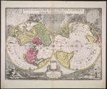
Novus Planiglobii Terrestris per Utrumque Polum Conspectus
Collection:
Osher Collection
Name: Novus Planiglobii Terrestris per Utrumque Polum Conspectus
Barcode: 537
Image Number: 537.0001
Creator: Blaeu, Joan, 1596-1673Valck, G. (Gerard), 1651-1726
From Atlas: No
Publishing Location: Amsterdam
Notes: Note at bottom: "Prostat Amstelaeodami Penes Gerardum Valck Caleographum in foro vulgo den Dam Sub signo Canis Excubantis cum Privilegio". The Smith collection has a copy of this map: SM-1695-11.
Title Translation: New map of the Globe with each side showing a view from either pole
Brief Description: Map of the world showing the Northern and Southern Hemispheres
Physical Description: 1 map in 2 hemispheres: colored, illustrated
Publisher: Valck, G. (Gerard), 1651-1726
Date/Date Range Produced: 1695
Date/Date Range Published: 1695
Language: Latin
Region Depicted: World
Map Type: Geographical
Dimensions: 54 x 41 cm. on sheet 50 x 59 cm.
Printing Process: Engraving
Printing Technique: Copper
Material Type: Paper
OCLC: 48898586
Accession Number: OS-1695-1
Donor: Osher
Subjects: Adam (Biblical figure)AnimalsAnthropomorphismarmillary sphereAstronomyBible storiesBlaeu, Joan, 1596-1673Cartouches, Ornamental (Decorative arts)Cherubs (Art)Devices (Heraldry)EdenEve (Biblical figure)Fall of manGalleonsMaps--Early works to 1800moonSailing shipsSunWorld mapsZodiac
Permanent URL:
https://oshermaps.org/map/537.0001