Showing 1911-1920 of 117288 results

Sort By:

Map of the British & French Plantations in North America
Publisher:
Date/Date Range Produced: 1755
Language:
Region Depicted:
Map Type:
Dimensions: H 22.1 X W 28 cm
Printing Process:
Material Type:
OCLC: 255332785
Accession Number: OML-1755-34
Image Number:


Plan and Survey of Pontefract Race Course; in the County of York including the Rises and Falls; with Notes Referring to an appendix, by Wm. Kemp.
Creator:
Date/Date Range Produced: 1825
Language:
Region Depicted:
Dimensions: 21 x 27 cm
Accession Number: OML-1825-14
Image Number:


Plan and Survey of Ascot Race Course in the County of Berks; including the Rises and Falls; with Notes Referring to an Appendix by Wm. Kemp.
Creator:
Date/Date Range Produced: 1824
Language:
Region Depicted:
Dimensions: 21 X 27 cm
Accession Number: OML-1824-9
Image Number:


Champlain's Map of New France 1632
Creator:
Date/Date Range Produced: 1850
Language:
Region Depicted:
Dimensions: 51 cm. x 72 cm. folds into cover 19 cm. x 9 cm.
Printing Process:
Material Type:
OCLC: 489253558
Accession Number: OML-1850-29
Image Number:


Africae Propiae Tabula, In qua, Punica regna uides; Tyrios, et Agenoris urbem.
Creator:
Date/Date Range Produced: 1608
Language:
Region Depicted:
Dimensions: 33 x 48 cm
Printing Process:
Material Type:
Physical Description: 1 map: illustrations, color
OCLC: 489255600
Accession Number: OML-1608-3
Donor:
Image Number:


Terra Firma et Novum Regnum Granatense et Popayan.
Creator:
Date/Date Range Produced: 1670
Language:
Region Depicted:
Dimensions: 28 x 35 cm
Printing Process:
Material Type:
OCLC: 489255469
Accession Number: OML-1670-9
Donor:
Image Number:


City of Manhattan or New York and Bay & Port of New York, Capital New York
Creator:
Date/Date Range Produced: 1861
Language:
Region Depicted:
Dimensions: 38 X 25 cm
Physical Description: 1 map: illustrated
LC Call Number: G3804.N4:2M3 1764 .B4 1861
Accession Number: OML-1861-17
Image Number:


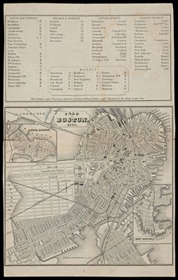
Plan of Boston, 1860.
Creator:
Alternative Title: Map of Boston and Vicinity 1860
Date/Date Range Produced: 1860
Language:
Region Depicted:
Map Type:
Dimensions: 13 x 13 cm and 11 x 13 cm on sheet 21 x 14 cm
OCLC: 586080656
Accession Number: OML-1860-29
Image Number:


Commonwealth of Virginia State Highway System and Connections
Creator:
Date/Date Range Produced: 1944
Language:
Dimensions: 52 x 100
Physical Description: 1 map: both sides color
LC Call Number: G3881.P2 1944 .V57
OCLC: 701908401
Accession Number: OML-1944-65
Donor:
Image Number: