Showing 191-200 of 109816 results

Sort By:

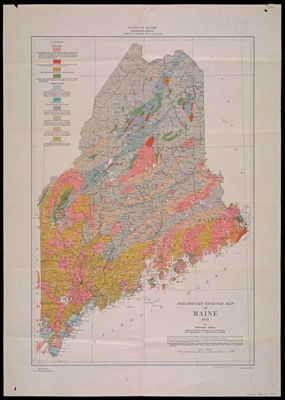
Preliminary Geologic Map of Maine by Arthur Keith
Creator:
Publisher:
Date/Date Range Produced: 1933
Language:
Region Depicted:
Map Type:
Dimensions: 51 x 35 cm.
Printing Process:
Material Type:
Brief Description: Colored geologic map of Maine, published by the U.S. Geological Survey.
LC Call Number: G3731 .C5 1933
OCLC: 22617803
Accession Number: OML-1933-7
Subjects:
Image Number:


Nuova pianta di Roma. New map of Rome. Neuer Stadtplan von Rom. Nouveau plan de Rome. Nuevo plano de Roma
Publisher:
Date Produced: 1972
Physical Description: col. map 80 x 62 cm. fold. in cover 17 x 12 cm
LC Call Number: G6714.R7E635 1972 .C3
OCLC: 5683718
Accession Number: AUL-1972-49
Donor:
Image Number:


Official Road Map Wisconsin
Date/Date Range Produced: 1935
Language:
Region Depicted:
Map Type:
Dimensions: 61 x 46 cm
LC Call Number: G4120.P2.R3.1935
OCLC: 62140208
Accession Number: OML-1935-13
Image Number:


A Pictorial Map of Spain and Portugal by Ernest Dudley Chase of Winchester Massachusetts
Creator:
Date/Date Range Produced: 1935
Language:
Region Depicted:
Map Type:
Dimensions: 43 x 59 cm
LC Call Number: G6541.A5 C4 1935
OCLC: 11199226
Accession Number: OML-1935-15
Image Number:


A Pictorial Map of Switzerland by Ernest Dudley Chase
Creator:
Date/Date Range Produced: 1936
Language:
Region Depicted:
Map Type:
Dimensions: 17 x 23 cm
LC Call Number: G6040 .C4 1936
OCLC: 124068988
Accession Number: OML-1936-29
Image Number:


Norway, Sweden, Denmark by Ernest Dudley Chase
Creator:
Date/Date Range Produced: 1937
Language:
Region Depicted:
Map Type:
Dimensions: 59 x 44 cm
LC Call Number: G6940 .C4 1937
OCLC: 11202908
Accession Number: OML-1937-27
Image Number:


Texaco Touring Map of Maine
Creator:
Publisher:
Date/Date Range Produced: 1938
Language:
Region Depicted:
Map Type:
Dimensions: 67 x 43 cm
Material Type:
LC Call Number: G3731.P2.R36.1938
OCLC: 61678621
Accession Number: OML-1938-12
Subjects:
Image Number:


Phillips Petroleum Company 1938 Official Road Map Colorado
Date/Date Range Produced: 1938
Language:
Region Depicted:
Map Type:
Dimensions: 44 x 59 cm
LC Call Number: G4311.P2.G6.1938
OCLC: 62140239
Accession Number: OML-1938-14
Image Number:


Europe a Pictorial Map by Ernest Dudley Chase
Creator:
Date/Date Range Produced: 1938
Language:
Region Depicted:
Map Type:
Dimensions: 43 x 58 cm
LC Call Number: G5700 .C4 1938
OCLC: 124068894
Accession Number: OML-1938-6
Image Number:


Pictorial Guide to Happy Mortoring in Maryland, Delaware, Virginia, and West Viriginia
Date/Date Range Produced: 1940
Language:
Region Depicted:
Map Type:
Dimensions: 54 x 79 cm
LC Call Number: G3841.P2.G4.1940
OCLC: 61678633
Accession Number: OML-1940-24
Image Number: