Showing 1721-1730 of 117177 results

Sort By:

Phillips' Map of Northern Maine East of the Allagash
Creator:
Date/Date Range Produced: 1970
Language:
Region Depicted:
Dimensions: 58 x 48 cm
OCLC: 34073689
Accession Number: OML-1970-29
Donor:
Image Number:


Phillips' Map of Northern Maine's Moosehead Allagash Region Headwaters of the Kennebec, St. John's, and Pennobscot Rivers
Creator:
Date/Date Range Produced: 1978
Language:
Region Depicted:
Dimensions: 54 x 42 cm
LC Call Number: G3732.M59 1963 .A9
Accession Number: OML-1978-14
Donor:
Image Number:


Plan de Paris, Avec Indication du Metropolitian
Publisher:
Date/Date Range Produced: 1951
Language:
Region Depicted:
Dimensions: 50 X 71.5 cm
LC Call Number: G5834.P2
Accession Number: OML-1951-161
Image Number:


Plan du Blocus Prague forme par S.M. Frederic Second, Roi de Prusse, du 7 hiai au 19 Juin 1757
Creator:
Date/Date Range Produced: 1757
Language:
Accession Number: OML-19xx-117
Image Number:


Plan of the Investiture of Ostend Surrenderd, 6 July, 1706 : for Mr. Tindal's continuation of Mr. Rapin's History of England
Creator:
Date/Date Range Produced: 1745 - 1750
Language:
Region Depicted:
Dimensions: 36 x 46 cm
OCLC: 618665294
Accession Number: OML-1750-19
Image Number:


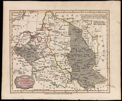
Poland : Shewing the Claims of Russia, Prussia and Austria from the best Authorities
Creator:
Publisher:
Date/Date Range Produced: 1806
Language:
Region Depicted:
Map Type:
Dimensions: 17 x 21 cm
Printing Process:
Material Type:
Historical Context: Map created for Blomfield's "A General View of the World" Possibly updated version of Dilly & Robinson's 1795 map of the Third Partition of Poland.
Accession Number: OML-1806-11
Image Number:


Poland previous to its Partition in 1795 between Russia, Austria & Prussia Shewing also its present extent of its territory.
Creator:
Date/Date Range Produced: 1830
Language:
Region Depicted:
Map Type:
Dimensions: 8 x 14 cm
OCLC: 618670335
Accession Number: OML-1830-13
Image Number:


Cape Town popout map
Publisher:
Date Produced: 2012
Donor:
Donation Date: Sep 1st, 2015
Image Number:


Oslo popout map : 5 maps
Publisher:
Date Produced: 2013
Accession Number: GIB-2013-23
Donor:
Donation Date: Sep 1st, 2013
Image Number:


Phoenix popout map : downtown & greater Phoenix, Scottsdale, Tempe, Tucson
Publisher:
Date Produced: 2008
Physical Description: 2 maps : color ; each 21 x 25 cm, jointly folded into cover 10 x 13 cm
OCLC: 668240855
Accession Number: GIB-2008-69
Donor:
Image Number: