Showing 221-230 of 109816 results

Sort By:

Map of Nanking & vicinity
Publisher:
Date/Date Range Produced: 1946
Dimensions: 96 x 57 cm.
Physical Description: col. map 45 x 51 cm
OCLC: 55664556
Accession Number: MO-1946-61
Donor:
Image Number:


Solomon Islands, Bougainville Island / prepared under the direction of the commanding general, Army Air Forces ; compiling and drafting by 955th Engr. Top. Co., 4th RCN and Map Group, 13th Air Force, July 1943
Publisher:
Date/Date Range Produced: 1943
Physical Description: 1 map : col. ; 42 x 37 cm
OCLC: 721312155
Accession Number: MO-1943-82
Donor:
Donation Date: Mar 1st, 2013
Image Number:


Topographic lunar map
Creator:
Date/Date Range Produced: 1964
Physical Description: 1 map on 2 sheets : col. ; 145 x 106 cm
OCLC: 28172583
Accession Number: MO-1964-101.1
Donor:
Donation Date: Mar 1st, 2013
Image Number:


Topographic lunar map
Creator:
Date/Date Range Produced: 1964
Physical Description: 1 map on 2 sheets : col. ; 145 x 106 cm
OCLC: 28172583
Accession Number: MO-1964-101.2
Donor:
Donation Date: Mar 1st, 2013
Image Number:


Japan
Japan
Creator:
Date/Date Range Produced: 1945
Language:
Region Depicted:
OCLC: 6315979
Accession Number: MO-1945-99
Donor:
Image Number:


Planning maps, scale 1:6,336,000: Australasia
Creator:
Date/Date Range Produced: 1945
Language:
Region Depicted:
Dimensions: 30 x 40 cm
Accession Number: MO-1945-100
Donor:
Image Number:


Texaco Touring Map of Illinois
Date/Date Range Produced: 1946
Language:
Region Depicted:
Map Type:
Dimensions: 77 x 47 cm
LC Call Number: G4101.P2 R36 1946
OCLC: 61680296
Accession Number: OML-1946-8
Image Number:


State Highway Department Road Map of Arizona
Date/Date Range Produced: 1948
Language:
Region Depicted:
Map Type:
Dimensions: 54 x 41 cm
LC Call Number: G4331.P2.R36.1948
OCLC: 61680299
Accession Number: OML-1948-9
Image Number:


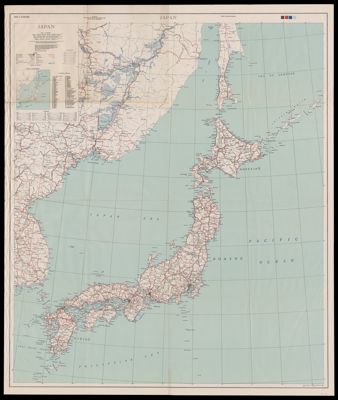
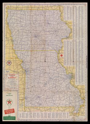
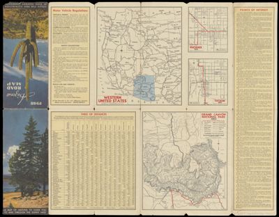
Philips' Motor Road Map of Great Britain.
Date/Date Range Produced: 1950
Language:
Dimensions: 112 x 84 cm. folded to 23 x 13 cm.
Physical Description: 1 map: colored, illustrated
LC Call Number: G5740.P2 P4 1950
OCLC: 62140263
Accession Number: OML-1950-11
Image Number:


Conoco Highway Map of United States featuring mileage and driving time along main transcontinental highways.
Date/Date Range Produced: 1950
Language:
Region Depicted:
Map Type:
Type:
Dimensions: 46 x 68 cm
LC Call Number: G3700.P2.G6.1950
OCLC: 61680389
Accession Number: OML-1950-9
Image Number: