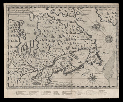
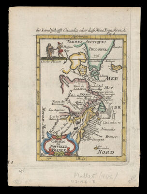
Description de la Novvelle France ou sont remarquees les diuerses habitations des Francois, depuis la premiere descouuerte jusques a present, receuillie et dressée sur diuerses relations modernes, 1643
Creator: Boisseau, Jean, active 1637-1658Publisher: Boisseau, Jean, active 1637-1658Date/Date Range Produced: 1643
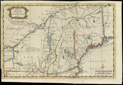
Language: FrenchRegion Depicted: ConnecticutDelawareEastern CanadaIllinoisIndianaMaineManitoba, CanadaMaritime ProvincesMarylandMassachusettsMichiganNew EnglandNew HampshireNew JerseyNew York (State)Newfoundland and LabradorNova ScotiaNunavut, CanadaOhioOntarioPennsylvaniaRhode IslandVermontWisconsinMap Type: GeographicalDimensions: H 42.2 x 56.5 cm
Printing Process: EngravingMaterial Type: PaperHistorical Context: Jean Boisseau took Champlain's large map of New France from 1632 and reduced it in size to make a more commercially viable product. He was, after all, a commercial cartographer and not a navigator. Although eleven years had passed since Champlain's original map had been published, Boiseau did not try to add any new details or place-names from any of the English or other French voyages. Instead, as has almost always been the case in commercial mapmaking, he simply copied his source directly. One benefit of Boisseau's reduction of Champlain's map is that it is now easier to contrast the configuration of New England on Champlain's original and later maps.
LC Call Number: G3400 1643 .B6
OCLC: 728356040
Accession Number: OS-1643-5
Donor: OsherSubjects: Boisseau, Jean, active 1637-1658Canada, EasternCartouches, Ornamental (Decorative arts)ConnecticutDelawareDevices (Heraldry)Great Lakes Region (North America)HeraldryIllinoisIndianaMaineManitobaMaps--Early works to 1800Maritime ProvincesMarylandMassachusettsMichiganNew EnglandNew FranceNew HampshireNew JerseyNew York (State)Newfoundland and LabradorNova Scotia (Canada)NunavutOhioOntarioPennsylvaniaQuebec (Province)Rhode IslandScrollworkVermontWisconsinImage Number: 425.0001