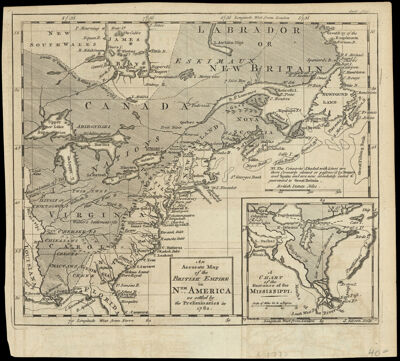
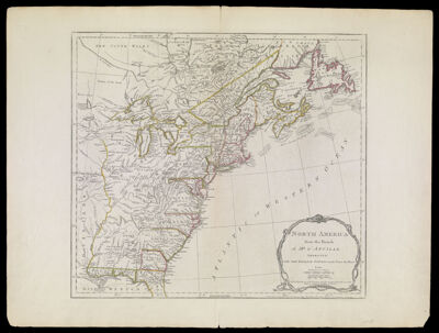
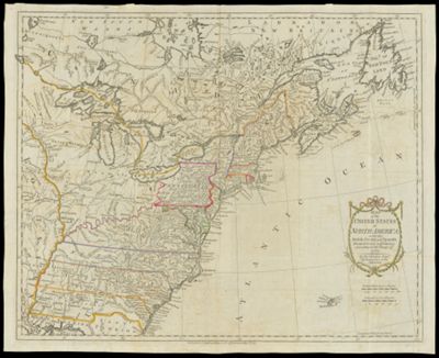
Map of the United States in North America with the British, French, and Spanish Dominions adjoining, according to the Treaty of 1783.
Creator: Kitchin, Thomas, 1718-1784Publisher: Cadell, Thomas, 1773-1836Language: EnglishRegion Depicted: AlabamaArkansasConnecticutDelawareEastern CanadaEastern United StatesFloridaGeorgiaIllinoisIndianaKentuckyLouisianaMaineMaritime ProvincesMarylandMassachusettsMichiganMinnesotaMississippiMissouriNew HampshireNew JerseyNew York (State)Newfoundland and LabradorNorth CarolinaNova ScotiaOhioOntarioPennsylvaniaRhode IslandSouth CarolinaTennesseeVermontVirginiaWest VirginiaWisconsinMap Type: GeographicalPolitical mapsDimensions: Map: 41 x 51 cm on sheet: 43.5 x 54 cm
Printing Process: EngravingMaterial Type: PaperHistorical Context: This map was one of the first to be published after the American Revolution. It presents the former colonies, early settlements, forts, Indian villages and fishing banks.
OCLC: 166636484
Accession Number: OS-1783-2
Donor: OsherSubjects: American Revolution, 1775-1783Colonial settlements in AmericaColonialismIndigenous locationsNative American tribesSettler-colonialismImage Number: 852.0001