Showing 11-20 of 30 results

Sort By:

The Roads from York to Whitby and Scarborough...
Creator:
Date Created: 1698
Printing Technique:
Image Number:


Map of Scarborough, Cumberland County, Maine
Creator:
Date/Date Range Produced: 1979
Dimensions: 102 x 74
LC Call Number: G3734.S4 M3 1979
Accession Number: OML-1979-94
Image Number:


Coastal sand dune map : Scarborough, Western and Ferry Beaches, Scarborough, Maine 
Publisher:
Date/Date Range Produced: 1990
Language:
Dimensions: 62 x 90 cm
LC Call Number: GB635.M2 D53 1990 No. 90-19
OCLC: 45187586
Accession Number: OML-1990-163.19
See Also:
Image Number:


Coastal sand dune map : Higgins Beach, Scarborough, Maine
Publisher:
Date/Date Range Produced: 1990
Language:
Dimensions: 62 x 90 cm
LC Call Number: GB635.M2 D53 1990 No. 90-8
OCLC: 45183132
Accession Number: OML-1990-163.8
See Also:
Image Number:


Scarborough's Topographic Map of the White Mountains and central New Hampshire.
Date/Date Range Produced: 1903
Language:
Dimensions: 92x97 cm. fold. to 25x13 cm
LC Call Number: G3742.W4 1903 .S237
OCLC: 1058707
Accession Number: OS-1903-10
Donor:
Image Number:


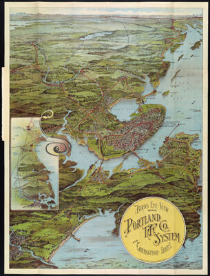
Birds Eye View showing Portland R.R. Co. System and Connecting Lines.
Creator:
Publisher:
Date/Date Range Produced: 1909
Language:
Region Depicted:
Map Type:
Dimensions: 69 x 52 cm.
Printing Process:
Material Type:
Historical Context: This 1909 transportation map presents a dramatic bird's eye view of the greater Portland metropolitan region served by a convenient inter-urban trolley system linking Brunswick, Lewiston, Old Orchard and other destinations. The growth of commuter suburbs and increased ridership of light rail was encouraged by company built terminal station attractions at Riverton Park and Cape Cottage in Cape Elizabeth. Produced by Walker Lithographers of Boston, this colorful map exemplifies the artistry which commercial printing had achieved at the turn of the century.
LC Call Number: G3731.P3 W3 1909
OCLC: 64282127
Accession Number: OS-1909-29
Donor:
Subjects:
Image Number:


Map of S. Portland-Cape Elizabeth Scarborough, Cumberland County, Maine
Creator:
Date/Date Range Produced: 1977
Dimensions: 78 x 99
LC Call Number: G3734.S73 M3 1977
Accession Number: OML-1977-68
Image Number:


Sheet 7 : Bartholomew's
Sheet 7 : Bartholomew's "half-inch to mile" map of England & Wales : York & Scarborough.
Date/Date Range Produced: 1920
Accession Number: MRS-1920-122
Donor:
Donation Date: Sep 1st, 2010
Image Number:


Map of Old Orchard Beach, York County, Scarborough Area, Cumberland County, Maine
Creator:
Date/Date Range Produced: 1988
Dimensions: 77 x 98
Accession Number: OML-1988-75
Image Number: