

Collection: Osher Map Library Collection
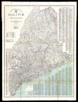
Name: The Official Map of Maine compiled from United States government surveys, official state surveys, and original sources; L.V. Crocker, Topographer.
Barcode:
Image Number:
Creator:
Publisher:
Publishing Location:
Notes: Map includes a key to the symbols showing boundary lines, railroads, steamship lines and lighthouses. Copy 1.
Date/Date Range Produced:
Date/Date Range Published:
Language:
Region Depicted:
Dimensions: 84 x 72
Physical Description: 1 map: color, illustrated
OCLC: 57224888
Accession Number: OML-1918-53
Donor:
Permanent URL: