“Sarah R. Allen, Map of North America, from “Manuscript Atlas of the World“, ca. 1830.
Louie Miller is the Osher Map Library and Smith Center for Cartographic Education’s Cartographic Reference and Teaching Librarian. He joined the OML staff in 2021, and works with hundreds of USM students and faculty each semester on customized learning experiences related to a wide variety of courses. As our reference librarian, he also answers dozens of reference queries each month, many of which involve deep dives into genealogical and newspaper research. This blog post is about process, the joys of research, and his ongoing quest to learn as much as he can about the materials in our collections.
One of my favorite genres of maps are what are often called “school girl” or “student” maps (for additional context, please read this passage from our 2019 exhibition Mapping the Classroom). I have always enjoyed looking at 19th century materials created by children and teenagers. I find it fascinating to compare what aspects of a child’s creative expression seem familiar, while noting the ways the vastly different cultural and educational circumstances of the United States in the early republic period shaped the ways that children visualized the world in which they lived. Unfortunately, as a librarian who is interested (i.e. obsessed) with tracking down the contexts of historical sources and those who created them, these student maps and atlases often prove frustrating. In many instances, the only information we have on the map’s creator is a first and last name, and that is if we are lucky.
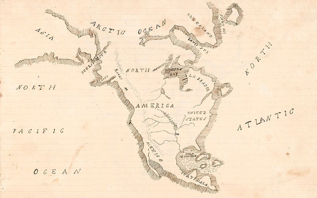
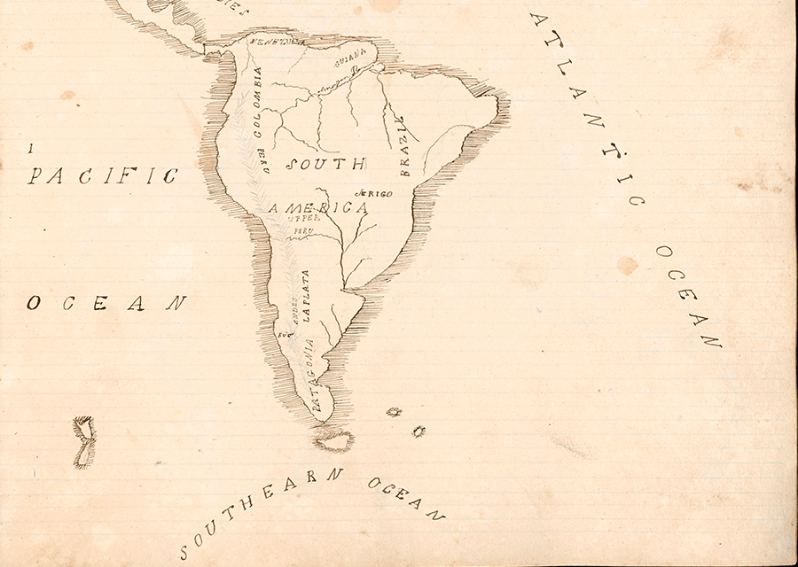
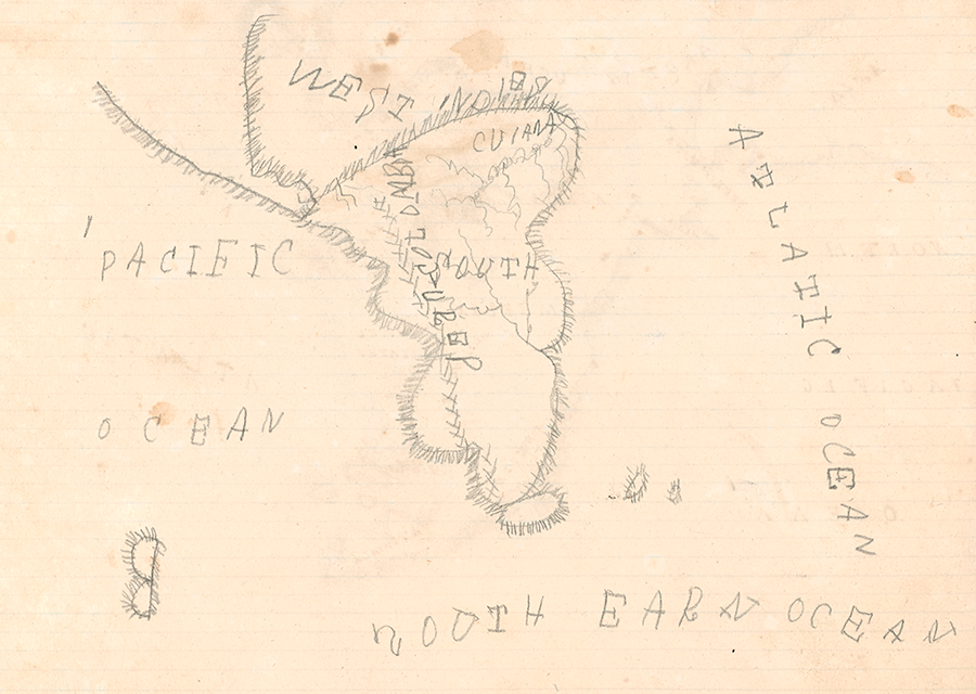
Sometimes, however, the stars align, and through both examining the source itself and using external resources we can gain a better understanding of an item, such as this manuscript atlas of the world created by a student ca. 1830. The reason this handmade school girl atlas initially caught my attention was because of the juxtaposition of high quality maps done in pen-and-ink on one side of the notebook’s pages with crude copies done in pencil on the other side, as exhibited below.
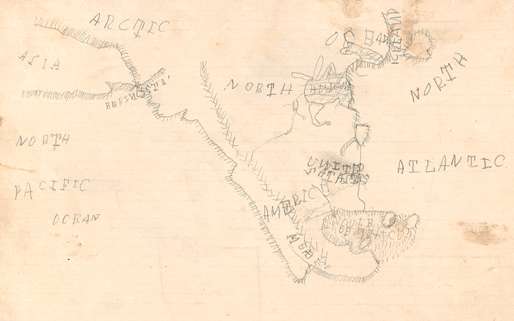
While it is fairly common to see evidence of pencil sketches a student initially used to draft their maps, I had never seen such poor-quality pencil drawings featured alongside high-quality pen and ink work. I then thought of my own experience as a parent, and had a suspicion that the lesser-quality maps may have been done by a young child–and not the same child as had produced the high-quality pen-and-ink maps. In my career thus far I have seen countless items that show evidence that the children, or other descendants of the item’s creator engaged with, scribbled on, and manipulated the original artifact passed down in families across generations. So, my initial thought was that these penciled maps were done by a child related to the person who made this atlas. Was it possible to discover more historical context that might provide evidence for my theory (beyond my parental spider-sense)?
The first clue was finding the name of the creator of the atlas. Since the majority of these maps were produced in childhood, finding biographical information can be difficult, especially if the creator is a woman who later married and took the name of her husband, as was customary in the United States in the 19th century. In the case of this particular manuscript atlas, we got lucky. On the front cover of the notebook the student used to create the atlas, we find the name “Sarah R. Allen” inscribed in ink.
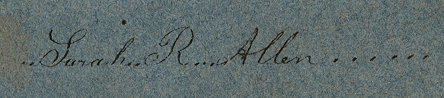
On the inside cover of the notebook we find another stenciled name, “Sarah R. Akin.”
And here is where the genealogical fun began. As a reference librarian, patrons frequently reach out to me to assist with tracking down genealogical information as related to maps and mapping. Using familysearch.org, I did a search for “Sarah R. Allen” and also put in my search that her spouse’s last name was “Akin.”
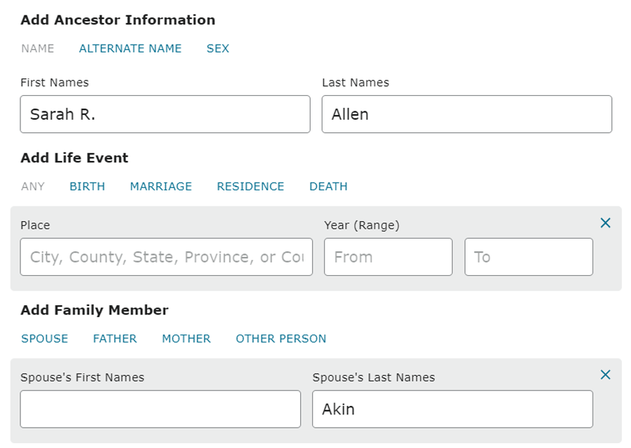
While this type of research often results in dozens of results needing to be sifted through, in this case the first hit was the result I was hoping to find:
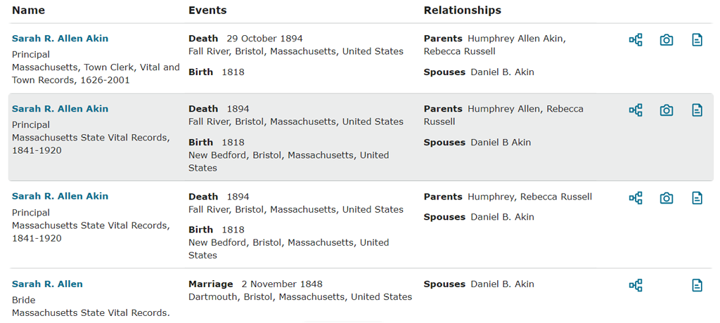
While the results from this database left me feeling 90+% certain I had found the creator of the manuscript atlas, I still wanted to see if there were any other pieces of information that might serve to further support my theory. And while there was no proverbial “smoking gun” (there almost never is), I did find a few more relevant bits of information
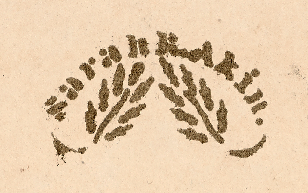
For example, there is this penciled inscription on a page of the atlas:

This inscription, “4th Mo 12 – 1861” is the Quaker way of writing the date, “April 12, 1861.” Deciphering this date led me to ask, was Sarah R. Allen a Quaker? It certainly appears so, given that she is buried in a Quaker cemetery. I found her gravestone on one of the best resources for locating genealogical and burial information, findagrave.com.
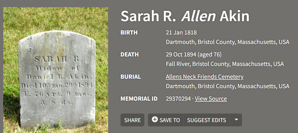
While none of the above pieces of evidence prove beyond a shadow of a doubt that the Sarah R. Allen who put together this atlas is the Sarah R. Allen who married Daniel Akin and died in 1894, it certainly seems that this is the case (at least in my opinion).
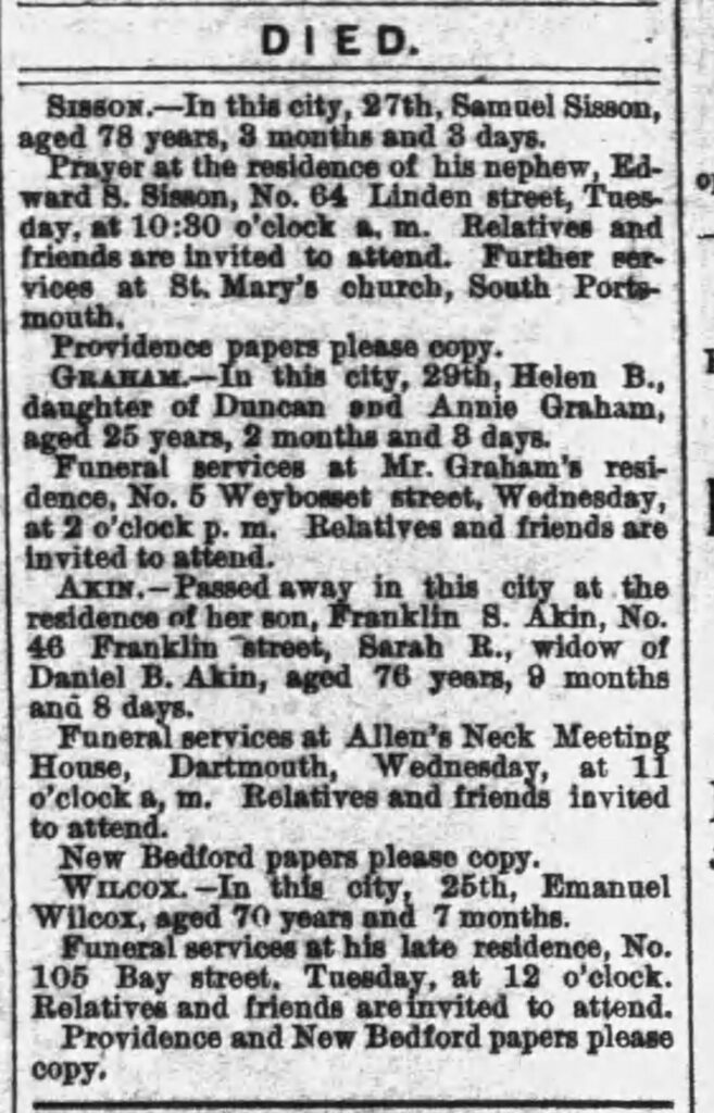
If we take the 1861 penciled date in the atlas to be made at approximately the same time as the child’s penciled copies of the maps, we have a few possible culprits that we can identify from the 1860 census: Sarah’s 10-year-old son Charles, or her 7-year-old son Frank. The obituary for Sarah R. Allen, which I tracked down on newspapers.com mentions that she died in the home of her son, Frank, which may mean that these were Frank’s drawings, and that the reason this atlas survived was because it was passed down from Sarah to Frank as a memento of his own childhood as well as his mother’s.
Another possibility is that the penciled maps were done by Sarah’s daughter Cornelia, who died at the age of 11 in 1867, and that Sarah kept the atlas as a memento mori for her daughter (or for her son, Charles, who died at the age of 25 in 1876).
It is important to recognize that while the research on this student atlas is backed up by numerous sources, it is still speculative in nature. I do truly believe, however, that we have identified the maker of this atlas, and that as a result, this item needs to be understood as having at least two “creators,” Sarah, and whichever of her children decided to go through their mother’s old school papers and practice their drawing and mapmaking skills. As someone who accidentally erased treasured family history as a youth who did not know any better, I have to wonder how much trouble the culprit got in when their “work” in their mother’s old notebook was discovered.
When I work with individual students and classes in the Osher Map Library and Smith Center for Cartographic Education, especially in courses like Research Methods for the Department of History, I intentionally take the time to discuss the importance of contextualizing sources like these manuscript materials. Sharing the process of research and discovery with students allows them to “see behind the curtain” so to speak. Explaining these tools and methods helps others to see how they might apply them to their own research projects. Uncovering the larger context of items created by women can be a particular challenge due to the less formal types of records left behind due to the gendered separation of the domestic vs. public sphere, and name changes from marriage and remarriage. In this example we were lucky to have both a maiden and married name, but that is not always the case. Walking students through the process gives them an example of how to start digging on their own and sharing my tips and tricks will hopefully allow more information to be discovered for other historical documents in our collections and beyond.
For more information about researching our collections and available resources, please visit oshermaps.org/research.