

Collection: Osher Collection
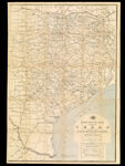
Name: Post route map of the state of Texas with adjacent parts of Louisiana, Arkansas, Indian Territory and the Republic of Mexico, showing post offices with the intermediate distances and mail routes in operation on the 1st of December 1884 published by order of Postmaster General Walter Q. Gresham under the direction of W.L. Nicholson, topographer P.O. Dept.
Barcode:
Image Number:
Creator:
Date/Date Range Produced:
Date/Date Range Published:
Language:
Dimensions: folded to 23 x 14 cm.
Notes: Includes chart of explanation of mail service. Handwritten on cover "Eastern Part" and the number "18".
Physical Description: "The first edition issued in 1878."
OCLC: 884825629
Accession Number: OS-1884-52
Permanent URL: