

Collection: Osher Collection
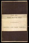
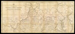
Name: Post Route Map of the states of Virginia and West Virginia together with Maryland and Delaware with the adjacent parts of Pennsylvania, Ohio, Kentucky, Tennessee and North Carolina showing post offices with the intermediate distances and mail routes in operation on the 1st of December 1884 / &c published by order of Postmaster General Walter Q. Gresham under the direction of W.L. Nicholson, topographer P.O. Dept.
Barcode:
Image Number:
Creator:
Date/Date Range Produced:
Date/Date Range Published:
Language:
Dimensions: folded to 21 x 14 cm.
Notes: Includes explanation of mail services. Handwritten on cover "Northern Part" and the number "11".
Physical Description: Mounted on linen.
OCLC: 884818266
Accession Number: OS-1884-49
Donor:
Permanent URL: