

Collection: Osher Collection
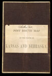
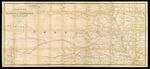
Name: Preliminary Post Route Map of the states of Kansas and Nebraska with the adjacent parts of Missouri, Iowa, Dakota, Colorado, Texas and Indian Territory showing post offices with intermediate distances and mail routes in operation on the 1st of December 1884 published by order of Postmaster General Walter Q. Gresham, under the direction of W.L. Nicholson, topographer P.O. Dept.
Barcode:
Image Number:
Creator:
Alternative Title:
Physical Description:
Date/Date Range Produced:
Date/Date Range Published:
Language:
Dimensions: folded to 20 x 15 cm.
Notes: Handwritten on cover number 10 and Northern Part.
OCLC: 884817677
Accession Number: OS-1884-48
Donor:
Permanent URL: