

Collection: Osher Collection
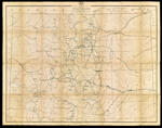
Name: Post route map of the state of Colorado showing post offices with the intermediate distances and mail routes in operation on the 1st of December 1884 published by order of Postmaster General Walter Q. Gresham under the direction of W.L. Nicholson, Topographer P.O. Dept.
Barcode:
Image Number:
Creator:
Date/Date Range Produced:
Date/Date Range Published:
Language:
Dimensions: folded to 23 x 15 cm
Notes: Mounted on linen. Includes a chart explaining the mail service. "20" on cover.
OCLC: 889349585
Accession Number: OS-1884-63
Donor:
Permanent URL: