

Collection: Osher Collection
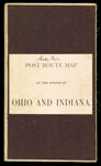
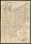
Name: Post route map of the states of Ohio and Indiana with adjacent parts of Pennsylvania, Michigan, Illinois, Kentucky and West Virginia showing post offices with the intermediate distances and mail routes in operation on the 1st of December 1884 published by order of Postmaster General Walter Q. Gresham under the direction of W.L. Nicholson, topographer P.O. Dept.
Barcode:
Image Number:
Creator:
Date/Date Range Produced:
Date/Date Range Published:
Language:
Dimensions: folded to 21 x 13 cm.
Notes: Inset map of the city of Cincinnati, Ohio.
Physical Description: "The service of this diagram brought up to date of Jan. 1st 1885." Includes chart of explanation of mail service. Handwritten on cover "Eastern Part."
OCLC: 884815588
Accession Number: OS-1885-54
Donor:
Permanent URL: