

Collection: Osher Collection
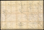
Name: Post route map of the territory of Dakota with adjacent parts of Montana, Wyoming, Nebraska, Iowa and Minnesota and portions of the Dominion of Canada showing post offices with the intermediate distances and mail routes in operation on the 1st of December 1884 published by order of Postmaster General Walter Q. Gresham under the direction of W.L. Nicholson, topographer P.O. Dept.
Barcode:
Image Number:
Creator:
Date/Date Range Produced:
Date/Date Range Published:
Language:
Dimensions: folded to 21 x 15 cm.
Notes: "The first edition was issued in 1879". "The service on this diagram brought up to date of Jan. 1st 1885."
OCLC: 889350678
Accession Number: OS-1885-53
Donor:
Permanent URL: