

Collection: Osher Collection
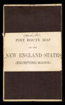
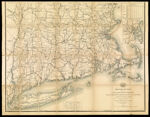
Name: Post route map of the states of New Hampshire, Vermont, Massachusetts, Rhode Island, Connecticut and parts of New York and Maine showing post offices with the intermediate distances and mail routes in operation on the 1st of December 1884 published by order of Postmaster General Walter Q. Gresham under the direction of W.L. Nicholson, topographer P.O. Dept.
Barcode:
Image Number:
Creator:
Alternative Title: Post route map of the New England states (excepting Maine)
Publisher:
Date/Date Range Produced:
Date/Date Range Published:
Language:
Region Depicted:
Dimensions: folded to 21 x 13 cm.
Notes: Handwritten on cover: "Southern Part." "The service on this diagram brought up to date of Dec. 1st 1884."Mounted on linen. Inset map of vicinity of Boston showing carrier stations of the free delivery of the Boston Post Office includes a distance chart.
OCLC: 889351155
Accession Number: OS-1884-72
Donor:
Permanent URL: