↑ Parent: Atlas Accompanying Volume I & IV. Geological Survey of Wisconsin.
Collection: Edney Collection
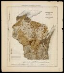
Name: General map of soils of Wisconsin 1882
Barcode: 36587
Image Number: 36587.0017
Creator: Chamberlin, Thomas Crowder, 1843-1928Milwaukee Lith. & Engr. Co.
Date Created: 1882
Date Published: 1882
Publisher: Wisconsin. Geological Survey
Permanent URL: https://oshermaps.org/map/36587.0017