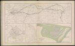
Map of the country between Vicksburg and Meridian, Miss. showing the route followed by the Seventeenth Army Corps under the command of Maj. Gen. J. B. McPherson in February, 1864.
↑ Parent: Atlas to accompany the Official Records of the Union and Confederate Armies published under the direction of the Hon. Stephen B. Elkins, Secretary of War Maj. George B. Davis U.S.A. Mr. Leslie J. Perry Mr. Joseph W. Kirkley Board of Publication Compiled by Capt. Colvin D. Cowles 23d. U.S. Infantry Part IX.
Collection:
Osher Collection
Name: Map of the country between Vicksburg and Meridian, Miss. showing the route followed by the Seventeenth Army Corps under the command of Maj. Gen. J. B. McPherson in February, 1864.
Barcode: 3776
Image Number: 3776.0003
Creator: Bush, H. M.Davis, George B. (George Breckenridge), 1847-1914Davis, S.Dunning, S. W.Hickenlooper, A.James, William H.McPherson, James Birdseye, 1828-1864
Date Created: 1864
Date Published: 1864
Alternative Title: Sketch of the city of Atlanta and line of defenses; Sketch of Battery; Map of Smith's Island, N.C.
Notes: "Sketch of the city of Atlanta and line of defenses" and "Sketch of Battery" have signature of possible authority, cannot make it out. L. P. something. Grant, maybe? Look into.
"February"
"April 12th"
"November"
1864 - Inscribed on Map; 1863 - Inscribed on Map
Permanent URL:
https://oshermaps.org/map/3776.0003