Previous Page         Next Page

Map of Oxford Co. Maine with portions of Coos Co. N.H. & Franklin Co. Me. Shewing the whole of the Androscoggin Lake District.


↑ Parent: Colby's Atlas of the State of Maine : including statistics and description of its history, educational system, geology, railroads, natural resources, summer resorts and manufacturing interests compiled and drawn from official plans and actual surveys and published by Colby & Stuart

Collection: Osher Collection

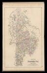
Name: Map of Oxford Co. Maine with portions of Coos Co. N.H. & Franklin Co. Me. Shewing the whole of the Androscoggin Lake District.

Barcode:

Image Number:

Creator:

Printmaker:

Date Published: 1887

Publisher:

Language:

Permanent URL: