↑ Parent: Cram's Complete War Atlas Covering Every Possible Scene of conflict: large scale map of Yellow Sea district, Japan-Russia, Pacific Ocean, Europe-Asia, the world, Panama Canal with interesting statistics.
Collection: Osher Map Library Collection
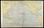
Name: Map of the Pacific Ocean showing distances between principal points and the International Date Line.
Barcode: 12225
Image Number: 12225.0008
Creator: Cram, George Franklin, 1841-1928
Date Created: 1904
Date Published: 1904
Permanent URL: https://oshermaps.org/map/12225.0008