

Collection: Smith Collection
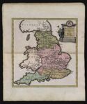
Name: Britanniae Romanae tabula Antonini Imp. Itinerario adaptata a Thoma Gale Norimbergae excudit. C. Weigelius.
Barcode:
Image Number:
Creator:
Date Created:
Date Published:
Language:
Region Depicted:
Printing Technique:
Notes: Antonini refers to the reign of the Antonine emperors.
Brief Description: Map of England during the Roman Empire which includes detailed depictions of Roman roads in England. Based on the writings of classical scholar Thomas Gale.
Permanent URL: