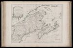
A New Map of Nova Scotia, and Cape Breton with the adjacent parts of New England and Canada...
↑ Parent: The American atlas or, A geographical description of the whole continent of America. Wherein are delineated at large, its several regions, countries, states, and islands and chiefly the British colonies. Engraved on 48 copper-plates, by Thomas Jefferys and others
Collection:
Smith Collection
Name: A New Map of Nova Scotia, and Cape Breton with the adjacent parts of New England and Canada...
Barcode: 1986
Image Number: 1986.0041
Creator: Jefferys, Thomas, 1710-1771
Date Published: Jun 15th, 1775
Content: Graphic
Publisher: Robert Sayer and John Bennett (Firm)
Language: English
Region Depicted: Cape Breton IslandGulf of Saint LawrenceNova Scotia
Dimensions: Map: H 47 x W 61 cm on sheet: H 54.5 x W 75.5 cm
Printing Process: Engraving
Printing Technique: Copper
Permanent URL:
https://oshermaps.org/map/1986.0041