Previous Page         Next Page

The Coast of West Florida and Louisiana


↑ Parent: The American atlas or, A geographical description of the whole continent of America. Wherein are delineated at large, its several regions, countries, states, and islands and chiefly the British colonies. Engraved on 48 copper-plates, by Thomas Jefferys and others

Collection: Smith Collection

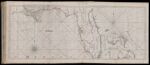
Name: The Coast of West Florida and Louisiana

Barcode:

Image Number:

Creator:

Date Published: Feb 20th, 1775

Content:

Subjects:

Publisher:

Language:

Region Depicted:

Dimensions: Map: H 47.5 x W 123 cm on sheet: H 55 x W 128 cm

Printing Process:

Printing Technique:

Permanent URL: