

Collection: Smith Collection
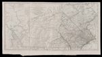
Name: A Map of Pennsylvania Exhibiting not only The improved Parts of that Province, but also its extensive Frontiers: Laid down From Actual Surveys and Chiefly from the late Map of W. Scull Published in 1770; and Humbly Inscribed to the Honouralbe Thomas Penn and Richard Penn Esquires Province of Pennsylvania and the Territories thereunto belonging
Barcode:
Image Number:
Creator:
Date Created:
Date Published:
Full Title: A Map of Pennsylvania Exhibiting not only The improved Parts of that Province, but also its extensive Frontiers: Laid down From Actual Surveys and Chiefly from the late Map of W. Scull Published in 1770; and Humbly Inscribed to the Honouralbe Thomas Penn and Richard Penn Esquires Province of Pennsylvania and the Territories thereunto belonging
Publisher:
Language:
Region Depicted:
Permanent URL: