

Collection: Osher Collection
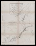
Name: A Map of a portion of the Country in dispute with the United States including the plain that separates the Highlands claimed by that Government, from the Highlands of the Treaty of 1783 in which latter Highlands, the northwesternmost head of Connecticut river takes its rise. Constructed by W. E. Delves Broughton Capt. Royal Engineers and James D. Featherstonehaugh
Barcode:
Image Number:
Creator:
Printmaker:
Full Title: A Map of a portion of the Country in dispute with the United States including the plain that separates the Highlands claimed by that Government, from the Highlands of the Treaty of 1783 in which latter Highlands, the northwesternmost head of Connecticut river takes its rise. Constructed by W. E. Delves Broughton Capt. Royal Engineers and James D. Featherstonehaugh
Publisher:
Language:
Dimensions: H 75.5 x W 58.5 cm
Permanent URL: