Atlas minimus or a book of geography shewing all the empires, monarchies, kingdomes, regions, dominions, principalities and countries in the whole world by John Seller, hydrographer to the king.
Author: Seller, John, active 1658-1698Language: EnglishDimensions: 12 x 8
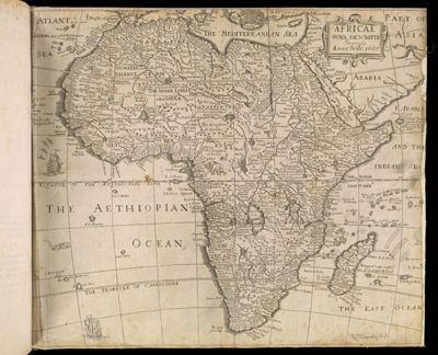
Physical Description: Comprises frontispiece, depicting a globe, with monogram of Charles II; t.p. with the royal arms; double-page world map within illustrated border; and 52 full-page maps, each with a brief descriptive text on facing page of conjugate leaf.
LC Call Number: G1015.S4 1679
OCLC: 905856398
Accession Number: SM-1679-4
Donor: Smith