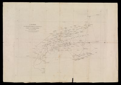
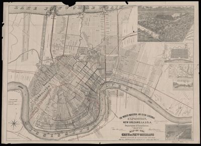
The World's Industrial and Cotton Centennial Exposition, New Orleans, La., U.S.A. : plan no. 2, map of the city of New Orleans, showing location of the Exposition Grounds and all approaches thereto by land and water
Creator: Anonymous / Unknown AuthorDate/Date Range Produced: 1884 - 1885
Language: EnglishRegion Depicted: New OrleansDimensions: 68 x 92 cm
Historical Context: The World's Industrial and Cotton Centennial Exposition, a lesser-known world's fair, was held in New Orleans, Louisiana, in 1884. Sponsored by Congress, the fair was constructed on 249 acres of relatively undeveloped land, on the site of a former sugar plantation purchased by the city for the creation of a park, and situated between the Mississippi River and St. Charles Avenue (now Audubon Park). Prior to the city's purchase of the land, it also served as a Civil War Hospital for Union soldiers, and a training ground for Buffalo Soldiers during Reconstruction. This map of the Exposition grounds and the City of New Orleans--then the nation's ninth largest city--endeavored to demonstrate to potential fairgoers the growth and development of the city over the course of a century, as well as numerous transportation networks by which one could arrive at the fair--by train, by horse-drawn streetcar, by steamboat, and via ocean-born ships. Like the fair itself, the map highlights the growth of the industrial South in the decades following the Civil War and Reconstruction.The Cotton Planters Association put forth the idea of holding the fair in New Orleans, as the city was responsible for handling nearly one-third of the cotton grown in the United States, and was home to a large Cotton Exchange, founded in 1871. 1884 was chosen to mark the 100th anniversary of the first documented sale of cotton from the United States to England, which occurred in 1784. While the fair ended deeply in debt, with many of the buildings subsequently dismantled and sold for scrap, the development of the park area also furthered the residential development of the Uptown neighborhood of the city. Because the fair predated the passage of Jim Crow laws in the city of New Orleans, both white and black citizens attended the fair and took part in its exhibits and entertainments.
OCLC: 19113497
Accession Number: OML-1885-48
Donor: Maine Historical SocietyDonation Date: Sep 1st, 2013