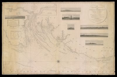
Osher Map Library Sheet Map Collection

4,633 results

The Cape Ann trail
Creator:
Date/Date Range Produced: 1930
Dimensions: 26 x 12
LC Call Number: G3762.C34 1930 .C4
OCLC: 861928970
Accession Number: OML-1930-147
Donor:
The Cape Ann trail

Map of the subway system of New York
Creator:
Publisher:
Date/Date Range Produced: 1940
LC Call Number: G3804.N5P33 1940 .V6
OCLC: 14706989
Accession Number: OML-1940-153
Donor:
Donation Date: Jan 5th, 2005
Map of the subway system of New York

Ireland : land of scenery and romance
Creator:
Date/Date Range Produced: 1931
LC Call Number: DA977 I74 1931
OCLC: 775871112
Accession Number: OML-1931-114
Donor:
Ireland : land of scenery and romance

The East Coast of England, from Folkstone to Haboroughgat: including all the channels of the River Thames up to London.
Creator:
Publisher:
Date/Date Range Produced: 1803
Language:
Region Depicted:
Dimensions: 81 x 127 cm
LC Call Number: G5752.P5 1803 S7
OCLC: 1003646323
Accession Number: OML-1803-4
The East Coast of England, from Folkstone to Haboroughgat: including all the channels of the River Thames up to London.

Middle and Near East
Publisher:
Date/Date Range Produced: 1951
Dimensions: Height: 74
LC Call Number: G7420 1951 .B3
OCLC: 45143397
Accession Number: OML-1951-98
Donor:
Middle and Near East

Ya Zhou di tu = Map of Asia
Date/Date Range Produced: 2003
Language:
OCLC: 671490705
Accession Number: OML-2000-104
Donor:
Donation Date: Jun 5th, 2003
Ya Zhou di tu = Map of Asia

Beijing shi qu tu = Beijing shiqutu
Date/Date Range Produced: 1987
Language:
OCLC: 17321300
Accession Number: OML-1987-68
Donor:
Beijing shi qu tu = Beijing shiqutu

Neotectonic map of Italy
Date/Date Range Produced: 1983
Language:
OCLC: 229070455
Accession Number: OML-1983-61
Donor:
Neotectonic map of Italy

Neotectonic map of Italy
Date/Date Range Produced: 1983
Language:
OCLC: 229070455
Accession Number: OML-1983-62
Donor:
Neotectonic map of Italy

A Sportsman's Map of Lincoln County, Maine: Keep Maine green, conserve wildlife published by Lincoln County Fish & Game Association.
Creator:
Publisher:
Date/Date Range Produced: 1952
Language:
Region Depicted:
Map Type:
Dimensions: 74 x 44 cm
OCLC: 891666863
Accession Number: OML-1952-93
A Sportsman's Map of Lincoln County, Maine: Keep Maine green, conserve wildlife published by Lincoln County Fish & Game Association.