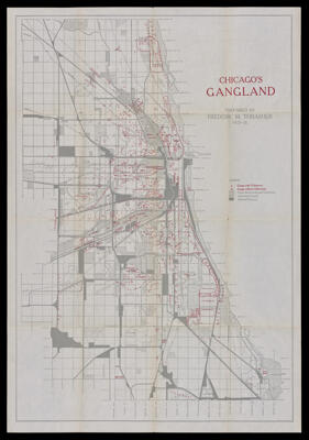
Chicago's Gangland.
Creator: Thrasher, Frederic Milton, 1892-1962Date/Date Range Produced: 1927
Language: EnglishRegion Depicted: Chicago, IllinoisDimensions: 65 x 45
Historical Context: This hand-drawn map of Chicago’s Gangland was printed and issued to illustrate University of Chicago Sociologist Frederic Thrasher’s 1926 book, "The Gang: A Study of 1,313 Gangs in Chicago," which was his PhD thesis, and is best interpreted in the context of the larger study. This complex thematic map supports a key argument of Thrasher's three years of research, in so far as he argued that "Gangland," represented “a geographically and socially interstitial area of the city.” He was most interested in mapping street gangs (with an estimated 25,000 members), and believed the map "makes it possible to visualize the typical areas of gangland and to indicate their place in the life and organization of Chicago.”In his legend, Thrasher distinguishes between different types of properties: Parks, Boulevards and Cemeteries; Industrial Property; and Railroad Property, all in various shades of gray. Additionally, he maps race, ethnicity, and religion onto Chicago's neighborhoods, also depicted in gray, e.g. noting the locations of "Polish," "Italian," "Bohemia," "Negro," "Jewish," "Dutch" areas, before adding an over-layer of red, locating and distinguishing "Gangs with Clubrooms" from "Gangs without Clubrooms," and adding formal and informal names for neighborhoods and enclaves, some rife with what we now consider as ethnic slurs. He has additional red notations throughout the map noting particular gang activities, e.g. "gambling," "coal-stealing," and "dope gangs," as well as demarcating particular areas of conflict between rival gangs. Thrasher was among the first to survey and map criminal activity.
LC Call Number: G4104.C6 E625 1926.T47
OCLC: 51300734
Accession Number: OML-1927-143