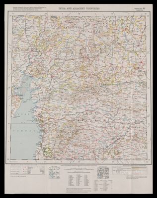
Osher Map Library Sheet Map Collection

4,633 results

India and adjacent countries
Date/Date Range Produced: 1936
Language:
Region Depicted:
Map Type:
Dimensions: 1 map : colored ; 45 x 42 cm on sheet 61 x 46 cm
LC Call Number: G7653 1936.S8
OCLC: 948201659
Accession Number: OML-1936-121
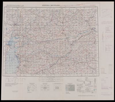
India and adjacent countries

Satpura Mountains
Date/Date Range Produced: 1941
Language:
Region Depicted:
Map Type:
Dimensions: 45 x 63 cm
LC Call Number: G7652 1941.S8
OCLC: 948200952
Accession Number: OML-1941-88
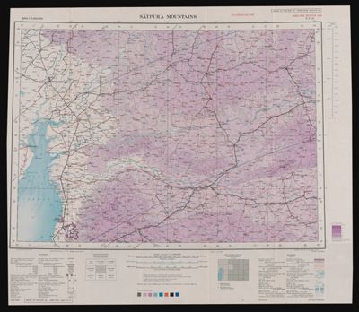
Satpura Mountains

Satpura Mountains
Language:
Region Depicted:
Map Type:
Dimensions: 45 x 63 cm
LC Call Number: G7652 1943.S8
OCLC: 948201657
Accession Number: OML-1943-100
Satpura Mountains

Plan of all the lands granted under the authority of New Brunswick on the northerly side of the River St. John and westward of the commissioners line signed Thos. Baillie, S. General.
Creator:
Date/Date Range Produced: 1845
Language:
Region Depicted:
Dimensions: 32 x 81 cm
LC Call Number: G3431.F2 1845 B3
OCLC: 948202802
Accession Number: OML-1845-44
Plan of all the lands granted under the authority of New Brunswick on the northerly side of the River St. John and westward of the commissioners line signed Thos. Baillie, S. General.

Copy of the plan which shews the original reserve at Dalhousie, New Brunswick.
Creator:
Date/Date Range Produced: 1845
Language:
Region Depicted:
Dimensions: 37 x 43 cm
LC Call Number: G3434.D3 1845 B3
OCLC: 948202626
Accession Number: OML-1845-42
Copy of the plan which shews the original reserve at Dalhousie, New Brunswick.

Copy of part of an official map whereon are delineated certain lots of land on the south side of the Ristigouche River granted by the Province of New Brunswick to Samuel Lee & others.
Creator:
Date/Date Range Produced: 1845
Language:
Region Depicted:
Map Type:
Dimensions: 34 x 19 cm
LC Call Number: G3432.R4 C6 1845
OCLC: 948203096
Accession Number: OML-1845-43
Copy of part of an official map whereon are delineated certain lots of land on the south side of the Ristigouche River granted by the Province of New Brunswick to Samuel Lee & others.

Serio-comique map of Europe at war : hark! hark! the dogs do bark! with note by Walter Emanuel
Creator:
Date/Date Range Produced: 1914
Language:
Dimensions: 48 x 70 cm
LC Call Number: G5701.S65 .J64 1914
OCLC: 55122706
Accession Number: OML-1914-105
Subjects:
Serio-comique map of Europe at war : hark! hark! the dogs do bark! with note by Walter Emanuel

Chart of the harbours of Salem, Marblehead, Beverly and Manchester from a survey taken in the years 1804, 5 & 6 by Nathl. Bowditch, AM. AAS; assisted by Geo. Burchmore & Wm. Ropes, 3rd.
Date/Date Range Produced: 1834
Language:
Region Depicted:
Map Type:
Dimensions: 53 x 65 cm
LC Call Number: G9112.S3 1834.B68
OCLC: 14947445
Accession Number: OML-1834-11
Donation Date: May 22nd, 2016
Chart of the harbours of Salem, Marblehead, Beverly and Manchester from a survey taken in the years 1804, 5 & 6 by Nathl. Bowditch, AM. AAS; assisted by Geo. Burchmore & Wm. Ropes, 3rd.

Neue Carte von Europa, welche die merkwurdigsten producte un vornehmsten Handelsplaze nebst den Flachen-Inhalt aller Europaischen Lander in deutschen Quadrat-Meilen enthalt von A.F.W. Crome.
Date/Date Range Produced: 1782
Language:
Dimensions: 43 x 50
LC Call Number: G5701.G1 1782.C7
OCLC: 904880160
Accession Number: OML-1782-11
Neue Carte von Europa, welche die merkwurdigsten producte un vornehmsten Handelsplaze nebst den Flachen-Inhalt aller Europaischen Lander in deutschen Quadrat-Meilen enthalt von A.F.W. Crome.