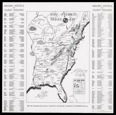
Osher Map Library Sheet Map Collection

4,456 results

Port Gamble, Washington Ter.
Publisher:
Date/Date Range Produced: 1858
Map Type:
Dimensions: 57 x 31 cm
Printing Process:
LC Call Number: G4284.P54P5 1858 .U5
OCLC: 21807986
Accession Number: OML-1858-57
Port Gamble, Washington Ter.

Preliminary chart of Kennebec River, Maine : from entrance to Bath
Publisher:
Date/Date Range Produced: 1858
Map Type:
Dimensions: 69 x 45 cm
Printing Process:
Accession Number: OML-1858-58
Preliminary chart of Kennebec River, Maine : from entrance to Bath

Preliminary chart of York River Virginia, from King's Creek to West Point
Publisher:
Date/Date Range Produced: 1858
Map Type:
Dimensions: 41 x 56 cm
Printing Process:
LC Call Number: G3882.Y6P5 1858 .U52
OCLC: 77225498
Accession Number: OML-1858-59
Preliminary chart of York River Virginia, from King's Creek to West Point

Comparative chart of New Inlet Bar, northern entrance of Cape Fear River, North Carolina
Publisher:
Date/Date Range Produced: 1858
Map Type:
Dimensions: 42 x 56 cm
Printing Process:
OCLC: 54884240
Accession Number: OML-1858-60
Comparative chart of New Inlet Bar, northern entrance of Cape Fear River, North Carolina

Sketch I, showing the progress of the survey in section no. IX from 1848 to 1858
Publisher:
Date/Date Range Produced: 1858
Map Type:
Dimensions: 25 x 58 cm
LC Call Number: G4032.C6 .P5 1858 .U55
OCLC: 46941573
Accession Number: OML-1858-61
Sketch I, showing the progress of the survey in section no. IX from 1848 to 1858

Reconnaissance of the coast of Texas between Matagorda and Corpus Christi Bays
Publisher:
Date/Date Range Produced: 1858
Map Type:
Dimensions: 35 x 50 cm
Printing Process:
LC Call Number: G4032.C6 P5 1858 .U55
OCLC: 46943034
Accession Number: OML-1858-63
Reconnaissance of the coast of Texas between Matagorda and Corpus Christi Bays

Sketch K showing the progress of the survey in Section no. XI : (upper sheet) : from Tillamook Bay to the boundary : from 1851 to 1858
Publisher:
Date/Date Range Produced: 1858
Map Type:
Dimensions: 63 x 45 cm
Printing Process:
OCLC: 68964496
Accession Number: OML-1858-64
Sketch K showing the progress of the survey in Section no. XI : (upper sheet) : from Tillamook Bay to the boundary : from 1851 to 1858

Sketch J showing the progress of the survey in section no. X (lower sheet) from San Diego to Pt. Sal from 1850 to 1858
Publisher:
Date/Date Range Produced: 1858
Map Type:
Dimensions: 75 x 50 cm
Printing Process:
Accession Number: OML-1858-65
Sketch J showing the progress of the survey in section no. X (lower sheet) from San Diego to Pt. Sal from 1850 to 1858

Preliminary chart of entrance to Brazos River, Texas
Publisher:
Date/Date Range Produced: 1858
Map Type:
Dimensions: 39 x 44 cm
Printing Process:
LC Call Number: G4032.B72 1858 .U54
OCLC: 1002196471
Accession Number: OML-1858-66
Preliminary chart of entrance to Brazos River, Texas