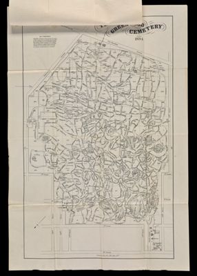
Osher Map Library Sheet Map Collection

4,456 results

The world, Van Der Grinten's spherical projection
Creator:
Publisher:
Date/Date Range Produced: 1909
OCLC: 743454890
Accession Number: OML-1909-134
The world, Van Der Grinten's spherical projection

Plan of the Sullivan Granite Co.'s lands in the town of Sullivan from a re-survey of the premises in 1874-5 by G.E. Simpson
Surveyor:
Date/Date Range Published: 1875
Language:
LC Call Number: G3734.S9 1875 S5
OCLC: 1105059316
Accession Number: OML-1875-77
Plan of the Sullivan Granite Co.'s  lands in the town of Sullivan from a re-survey of the premises in 1874-5 by G.E. Simpson

Sketch map of Sebago Lake Maine
Creator:
Date/Date Range Produced: 1906
Map Type:
Dimensions: 92 x 61 cm
Accession Number: OML-1906-132
Sketch map of Sebago Lake Maine

Combined Sewer Overflows, Portland, Maine: CSO Drainage Areas
Creator:
Publisher:
Date/Date Range Produced: 1995
Dimensions: 92 x 95 cm
Accession Number: OML-1995-125
Donor:
Donation Date: Aug 4th, 2010
Combined Sewer Overflows, Portland, Maine: CSO Drainage Areas

Casco Bay Bathymetry
Publisher:
Region Depicted:
Map Type:
Dimensions: 84 x 108 cm
Accession Number: OML-1995-126
Donor:
Donation Date: Aug 4th, 2010
Casco Bay Bathymetry

Eastern part of Long Island Sound
Publisher:
Date/Date Range Produced: 1878
Map Type:
Dimensions: 60 x 88 cm
LC Call Number: G3802.L61P5 1878 .U5
OCLC: 18307385
Accession Number: OML-1878-63
Eastern part of Long Island Sound

Birds-Eye View of Andersonville Prison from the south-east
Publisher:
Date/Date Range Published: 1890
Language:
Map Type:
Dimensions: 36 x 49 cm on sheet 40 x 51 cm
LC Call Number: G3924.A43:2A5 1890 M6
OCLC: 1105931293
Accession Number: OML-1890-103
Birds-Eye View of Andersonville Prison from the south-east

National Soldier's Home. Eastern Branch, near Augusta, Me. 1872.
Creator:
Publisher:
Language:
Region Depicted:
Map Type:
Dimensions: 40 x 67 cm on board 48 x 70 cm
LC Call Number: G3734.A9 1972 B3
OCLC: 1105931824
Accession Number: OML-1872-60
Subjects:
National Soldier's Home. Eastern Branch, near Augusta, Me. 1872.

Hammond's map of the Mediterranean, Europe and Northern Africa
Publisher:
Date/Date Range Produced: 1943
LC Call Number: G5671.S7 1943 .H36
OCLC: 56091381
Accession Number: OML-1943-140
Hammond's map of the Mediterranean, Europe and Northern Africa

Presidential World Atlas
Publisher:
Date/Date Range Produced: 1940
Dimensions: 91 x 70 cm
Accession Number: OML-1940-212
Presidential World Atlas