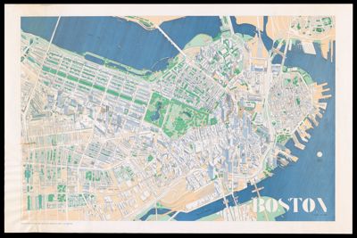
Osher Map Library Sheet Map Collection

4,693 results

Boston
Creator:
Date/Date Range Produced: 1983
Language:
Region Depicted:
LC Call Number: G3764.B6A3 1983 .F6
OCLC: 15657762
Accession Number: OML-1983-109
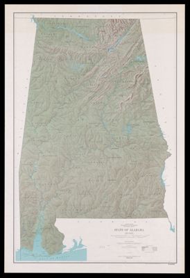
Boston

State of Alabama
Publisher:
Date/Date Range Produced: 1970
Language:
Region Depicted:
Dimensions: 111 x 72 cm
LC Call Number: G3971.C2 1970 .G4
OCLC: 35771509
Accession Number: OML-1970-176
State of Alabama

Massachusetts/Townfinder Map
Publisher:
Date/Date Range Produced: 1985
Language:
Region Depicted:
Dimensions: 56 x 87 cm
Accession Number: OML-1985-119
Massachusetts/Townfinder Map

Australia : no longer down under
Creator:
Date/Date Range Produced: 1984
Language:
Region Depicted:
LC Call Number: G3201.A67 1984 .H6
OCLC: 19598722
Accession Number: OML-1984-137
Australia : no longer down under

Geologic map of the Grand Canyon National Park, Arizona
Publisher:
Date/Date Range Produced: 1976
LC Call Number: G4332.G7C5 1976 .G7
OCLC: 5482872
Accession Number: OML-1976-148
Geologic map of the Grand Canyon National Park, Arizona

Geologic map of Mars
Publisher:
Date/Date Range Produced: 1978
Map Type:
OCLC: 4482504
Accession Number: OML-1978-126
Geologic map of Mars

Geologic map of New Hampshire
Publisher:
Date/Date Range Produced: 1955
Map Type:
OCLC: 919189804
Accession Number: OML-1955-131
Geologic map of New Hampshire

A Chart of the Banks of Newfoundland drawn from a great number of hydrographical surveys, chiefly from those of Chabert, Cook, and Fleurieu, connected and ascertained by astronomical observations.
Creator:
Date/Date Range Produced: 1775
Language:
Region Depicted:
Dimensions: 50 x 67 cm
LC Call Number: G9112.G65P5 1775.C5
OCLC: 5410338
Accession Number: OML-1775-32
A Chart of the Banks of Newfoundland drawn from a great number of hydrographical surveys, chiefly from those of Chabert, Cook, and Fleurieu, connected and ascertained by astronomical observations.