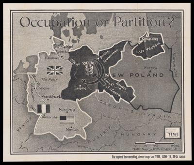
Osher Map Library Sheet Map Collection

4,456 results

Pictorial History of Boston
Publisher:
Date/Date Range Produced: 1880
Dimensions: 41 x 58 cm
Accession Number: OML-1880-77
Pictorial History of Boston

Support the Black Liberation Army & All New Afrikan Liberation Fighters
Publisher:
Date/Date Range Produced: 1981
Language:
Dimensions: 55 x 42 cm
Accession Number: OML-1981-114
Support the Black Liberation Army & All New Afrikan Liberation Fighters

Geographical Guide to a Man's Heart / Geographical Guide to a Woman's Heart
Creator:
Publisher:
Date/Date Range Produced: 1960
Language:
Dimensions: 34 x 54 cm
Accession Number: OML-1960-215
Geographical Guide to a Man's Heart / Geographical Guide to a Woman's Heart

[Decorative ceramic plate showing map of Panama Canal region]
Date/Date Range Produced: 1915
Accession Number: OML-1915-112
[Decorative ceramic plate showing map of Panama Canal region]

[Survey of Edward H. Rogers Property]
Date/Date Range Produced: 1900
Language:
Region Depicted:
Map Type:
Dimensions: 1 map; 45 x 92 cm
Historical Context: The trustees listed on the survey were F.W. Rogers and E.H. Rogers. Frederick W. Rogers and Edward H. Rogers were active in real estate in the Boston area in the late 19th and early 20th centuries. The approximate date of 1900 for this plan is based on the 1900 Sanborn Atlas of Cambridge as well as the 1894 and 1903 editions of the Atlas of the City of Cambridge.

The Roger Fibre Company purchased the National Fibre Company its mills at Bar Mills, East Poland, and Kennebunk, The Leatherroid Mfg. Company at Kennebunk, and The Mousam Counter Co. in Kennebunk in 1918. Main offices were located in Boston.
LC Call Number: G3734.K42 1900
OCLC: 1124768687
Accession Number: OML-1900-216
[Survey of Edward H. Rogers Property]

Richfield news map of Europe
Publisher:
Date/Date Range Produced: 1939
Accession Number: OML-1939-180
Donor:
Donation Date: Oct 22nd, 2019
Subjects:
Richfield news map of Europe

Lowell Thomas' War Map of the World
Creator:
Publisher:
Date/Date Range Produced: 1942
OCLC: 707925743
Accession Number: OML-1942-206
Donor:
Donation Date: Oct 22nd, 2019
Subjects:
Lowell Thomas' War Map of the World

Richmond, Va.
Printmaker:
Language:
Map Type:
Dimensions: H 38 x W 47 cm
Printing Process:
LC Call Number: E457.8 1865 R5
OCLC: 191117560
Accession Number: OML-1865-39
Richmond, Va.

Le Comté le Brie
Creator:
Date/Date Range Published: 1633
Language:
Dimensions: H 37 x W 49 cm
LC Call Number: G5832.S5 1633 H6
OCLC: 1124855615
Accession Number: OML-1633-19
Le Comté le Brie

New - York Tribune. Vol. XXV...No. 7,591. New - York, Saturday, August 5, 1865. [An admirable and correct map of the Atlantic telegraph company]
Publisher:
Date/Date Range Published: 1865
Language:
Region Depicted:
Map Type:
Dimensions: Map: H 18 x 45 cm. Newspaper page: H 53.5 x W 41 cm
Material Type:
Historical Context: The USS Arctic was commissioned to make depth soundings to prepare for the laying of the first transatlantic telegraph cable. In July 1856 the Arctic began soundings at St. John in Newfoundland and then all the way to Queenstown in Ireland on August 23, 1856. More soundings were taken on the return trip to St. John in September. The first cable failed in 1858 after sending 732 messages. New cable was laid beginning in 1865.
LC Call Number: G9101.P92 1865 N4
OCLC: 1130062746
Accession Number: OML-1865-40
New - York Tribune. Vol. XXV...No. 7,591. New - York, Saturday, August 5, 1865. [An admirable and correct map of the Atlantic telegraph company]