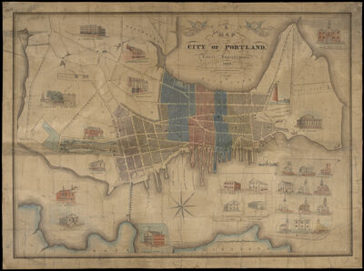
A Map of the City of Portland with its Latest Improvements including a view of the principal buildings engraved and published by John Cullum, Portland.
Creator: Cullum, JohnPublisher: Cullum, JohnDate/Date Range Produced: 1836
Language: EnglishRegion Depicted: Portland, MaineDimensions: 38 x 50 cm
Printing Process: EngravingMaterial Type: PaperHistorical Context: John Cullum, a printer and engraver, came to Portland, Maine, from Boston in 1832, the same year Maine's state capitol was moved from Portland to Augusta, and Portland was chartered as a city. By 1836, he had engraved this large map of the city, and boasted of his accomplishment in the October 25, 1836, issue of The Daily Advertiser, writing "A new map of Portland has been published by Mr. Cullum. The Wards are all marked off, and colored. The streets are distinctly pointed out. [...] all persons will find it eminently useful."This “city by the sea,” as the poet Henry Wadsworth Longfellow later wrote, was a city of ships and seaborne trade. Two angels in the cartouche herald the newly chartered city, and the map celebrates its mercantile and moral successes. At first glance, it is readily apparent that Portland’s principal buildings were its many churches of various sizes and denominations, as well as businesses and hotels. This is a map for a city proud of its present and hopeful for its future.A closer look reveals that this map is a document that contributes to making Maine’s Black history more visible. One of the buildings featured on the map is the Abyssinian Meeting House, constructed between 1828 and 1831 to serve Portland’s Black community as a church, a gathering place, a community center and a school. Cullum’s rendering of the Abyssinian Meeting House on his map is the first known published image of the Abyssinian, and, as such, is important to the building's ongoing restoration. The Abyssinian Meeting House, a place of gathering for the city's Black community, built by and for the Black community was both a “principal building” and a “latest improvement” in 1836 Portland. This map doesn’t depict the city’s residents or their occupations, but we can see the geography and the built environment, and if we wandered the wharves, went into the ropewalks, and opened the doors of the Abyssinian and the houses that surround it, we would see a vibrant Black community in a growing maritime city.
LC Call Number: G3734.P8 1836 .C8
OCLC: 893907613
Accession Number: OML-1836-5