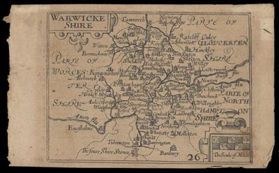
Osher Map Library Sheet Map Collection

4,456 results

Map no. 1 Carrington's Outline of Indian Operations on the Plains
Publisher:
Date/Date Range Published: 1878
Language:
Region Depicted:
Map Type:
Dimensions: 20 x 41 cm
LC Call Number: G4050 1878
OCLC: 1031394186
Accession Number: OML-1878-68
Map no. 1 Carrington's Outline of Indian Operations on the Plains

Map of the Alaska-Klondyke Regions : showing direct routes to the Yukon goldfields.
Publisher:
Date/Date Range Published: 1897
Language:
Region Depicted:
Accession Number: OML-1897-71
Map of the Alaska-Klondyke Regions : showing direct routes to the Yukon goldfields.

Map of the Island of Barbadoes for the history of the West Indies by Bryan Edwards
Creator:
Publisher:
Date/Date Range Produced: 1794
Language:
Region Depicted:
Map Type:
Dimensions: 23 x 18 cm on sheet 27 x 23 cm
LC Call Number: G5141.F33 1794 E3
OCLC: 1158460018
Accession Number: OML-1794-31
Map of the Island of Barbadoes for the history of the West Indies by Bryan Edwards

Defense map of America more of America's military camps and bases are served by Greyhound than by any other transportation system.
Publisher:
Date/Date Range Published: 1941
Language:
Region Depicted:
Map Type:
Dimensions: 46 x 61 cm folded to 23 x 10 cm
Historical Context: World War II
LC Call Number: G3701.R2 1941 G7
OCLC: 984127785
Accession Number: OML-1941-140
Subjects:
Defense map of America more of America's military camps and bases are served by Greyhound than by any other transportation system.

A good natured map of the United States setting forth the services of the Greyhound Lines and a few principal connecting lines
Publisher:
Language:
Region Depicted:
Map Type:
Dimensions: 29 x 48 cm folded to 16 x 10 cm
LC Call Number: G3701.P22 1940 G7
OCLC: 1162817011
Accession Number: OML-1940-217
A good natured map of the United States setting forth the services of the Greyhound Lines and a few principal connecting lines

[Reynold's political map of the United States designed to exhibit the comparative area of the free and slave states and the territory open to slavery or freedom : by the repeal of the Missouri Compromise with a comparison of the principal statistics o
Creator:
Language:
Region Depicted:
Dimensions: 48 x 70 cm on sheet 57 x 79 cm
Historical Context: John Fremont ran against James Buchanan in the 1856 campaign which was dominated by whether or not repeal the Kansas-Nebraska Act of 1854 which allowed new states the option to permit slavery. Buchanan supported the Act and Fremont did not. The Act launched "Bloody Kansas" and would lead to the Civil War.
LC Call Number: G3701.E9 1856 R4
OCLC: 1162817467
Accession Number: OML-1856-57
[Reynold's political map of the United States designed to exhibit the comparative area of the free and slave states and the territory open to slavery or freedom : by the repeal of the Missouri Compromise with a comparison of the principal statistics o

Elections 72
Publisher:
Date/Date Range Published: 1972
Language:
Map Type:
Dimensions: 45 x 60 cm folded to 23 x 10 cm
LC Call Number: G3706.F6 1972 R3
OCLC: 1164806635
Accession Number: OML-1972-157
Elections 72

Suggested Relief Map of the United States
Publisher:
Date/Date Range Published: 1926
Language:
Region Depicted:
Map Type:
Dimensions: 24 x 36 cm on sheet 28 x 40 cm
LC Call Number: G3700 1926.J8
OCLC: 1178877951
Accession Number: OML-1926-177
Suggested Relief Map of the United States