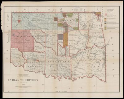
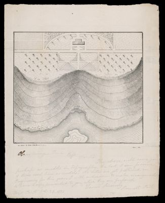
Models of Topography
Creator: Brown, Theophilus B., 1799?-1834Date/Date Range Produced: 1831
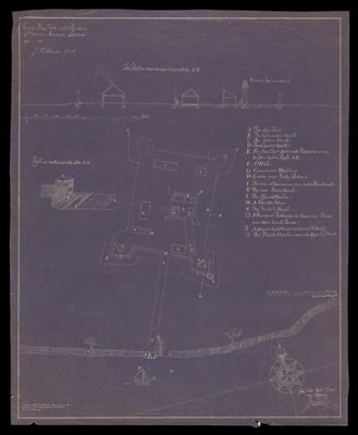
Language: EnglishMap Type: Topographical mapsDimensions: 2 maps; 17 x 20 cm on 29 x 24 cm AND 19 x 19 cm on sheet 29 x 24 cm
Printing Process: LithographHistorical Context: Two sheets sent by letter from Roswell Park (1808 - 1869) to Charlemagne Tower (1808-1889) . Park was a recent graduate of West Point, who went on to serve as an engineer for the military until his resignation. He published the first military history of West Point in 1840. He became an academic and Episcopal clergyman. He fought for the south as a captain with the 2nd Arkansas Infantry. Charlemagne Tower at the time of the letter was a recent graduate of Harvard. He went on to become a lawyer and businessman. He was active in acquiring land for mining anthracite in Schuylkill County , Pennsylvania. During the Civil War he was commissioned as a unit captain and worked to enforce conscription, in this way he was known in reference to the 'Molly Maguires'. Following the war he bought large tracts of land in the Dakotas and Minnesota. He is regarded as a leader in mining in Minnesota and there are several towns named after him.
LC Call Number: GA 125 1831 .B7
OCLC: 1130063092
Accession Number: OML-1831-45
![New - York Tribune. Vol. XXV...No. 7,591. New - York, Saturday, August 5, 1865. [An admirable and correct map of the Atlantic telegraph company]](https://cdn1.historyit.com/iiif/2/5f34291499c4a6.60628694/66f2f774a1c5a6.52094820.jpg/full/!400,400/0/default.jpg?no_errors=1)