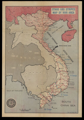
Osher Map Library Sheet Map Collection

4,457 results

Roman empire about 400 A.D., and the Barbarian invasions
Creator:
Publisher:
Date/Date Range Produced: 1980
Map Type:
Dimensions: 91 x 122 cm
OCLC: 18527847
Accession Number: OML-1980-169
Roman empire about 400 A.D., and the Barbarian invasions

Roman Empire about 120 A.D.
Creator:
Publisher:
Date/Date Range Produced: 1980
Map Type:
Dimensions: 91 x 122 cm
OCLC: 18519505
Accession Number: OML-1980-170
Roman Empire about 120 A.D.

Europe in 1810 : at the height of Napoleon's power
Creator:
Publisher:
Date/Date Range Produced: 1980
Map Type:
Dimensions: 79 x 122 cm
OCLC: 18528322
Accession Number: OML-1980-171
Europe in 1810 : at the height of Napoleon's power

Europe about 1560
Creator:
Publisher:
Date/Date Range Produced: 1980
Map Type:
Dimensions: 79 x 122 cm
Accession Number: OML-1980-172
Europe about 1560

Eurasia : the growth of civilization to 200 A.D.
Creator:
Publisher:
Date/Date Range Produced: 1980
Map Type:
Dimensions: 92 x 122 cm
OCLC: 18513794
Accession Number: OML-1980-173
Eurasia : the growth of civilization to 200 A.D.

Map of Greater Boston
Publisher:
Date/Date Range Produced: 1976
Map Type:
Dimensions: 94 x 62 cm
Accession Number: OML-1976-154
Map of Greater Boston

Political World
Publisher:
Date/Date Range Produced: 1958
Map Type:
Dimensions: 152 x 209 cm
Accession Number: OML-1958-140
Political World

Tectonic map of the United States, exclusive of Alaska and Hawaii
Publisher:
Date/Date Range Produced: 1962
Map Type:
Dimensions: 120 x 194 cm
OCLC: 61572525
Accession Number: OML-1962-146
Tectonic map of the United States, exclusive of Alaska and Hawaii

Schweiz
Creator:
Date/Date Range Produced: 1962
Region Depicted:
Map Type:
Dimensions: 157 x 201 cm
OCLC: 41589324
Accession Number: AUL-1962-147
Donor:
Donation Date: Jan 31st, 2014
Subjects:
Schweiz

Philips' series of physical large school maps, Europe
Publisher:
Date/Date Range Produced: 1963
Map Type:
Dimensions: 145 x 172 cm
Accession Number: AUL-1963-182
Donor:
Donation Date: Jan 31st, 2014
Philips' series of physical large school maps, Europe