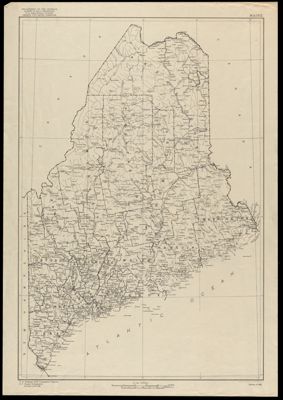
Osher Map Library Sheet Map Collection

4,454 results

Map of Asia and Adjoining Europe with a Portion of Africa
Date/Date Range Produced: 1921
Language:
Accession Number: OML-1921-32
Donor:
Map of Asia and Adjoining Europe with a Portion of Africa

Atlantic Ocean
Publisher:
Date/Date Range Produced: 1941
Language:
LC Call Number: G9100 1941 .N3
OCLC: 20820731
Accession Number: OML-1941-28
Donor:
Atlantic Ocean

Central Europe and the Mediterranean as of September 1, 1939
Publisher:
Date/Date Range Produced: 1939
Language:
LC Call Number: G5700 1939 .N3
OCLC: 6470901
Accession Number: OML-1939-24
Donor:
Central Europe and the Mediterranean as of September 1, 1939

Austria. From the best Authorities.
Creator:
Date/Date Range Produced: 1808
Language:
Dimensions: sheet: 56 cm. x 75 cm.
Printing Process:
Material Type:
Accession Number: OML-1808-6
Donor:
Austria. From the best Authorities.

Lugdunum Batavorum Vulgo Leyden
Date/Date Range Produced: 1649
Language:
Dimensions: 46 x 33
Accession Number: OML-1649-6
Donor:
Lugdunum Batavorum Vulgo Leyden

Map of the City of Boston
Creator:
Date/Date Range Produced: 1905
Language:
Dimensions: 24 x 31
Accession Number: OML-1905-42
Donor:
Map of the City of Boston

Italy.
Date/Date Range Produced: 1860
Language:
Dimensions: 41 cm. x 29 cm.
Accession Number: OML-1860-21
Donor:
Italy.

Cook's Map of Europe Showing Principal Railway and Steamship Routes
Date/Date Range Produced: 1955
Language:
Dimensions: 55 x 88 cm folded to 23 x 15 cm
LC Call Number: G5701.P3 1955 .G4
OCLC: 68816227
Accession Number: OML-1955-36
Cook's Map of Europe Showing Principal Railway and Steamship Routes

Colton's Maine
Creator:
Publisher:
Date/Date Range Produced: 1867
Language:
Region Depicted:
Dimensions: 21 x 26
LC Call Number: G3730 1867 .C6
Accession Number: OML-1867-19
Colton's Maine