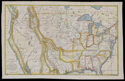
Outline Map of Indian Localities in 1833.Creator:Catlin, George, 1796-1872 Language:English Region Depicted:United States Map Type:GeographicalHistorical maps Dimensions: 23 x 37 cm on sheet 25 x 40 cm Historical Context: Between 1831 and 1877, the Indian Removal Act, signed by President Andrew Jackson on May 28, 1830 which expanded Anglo-American settlement west of Mississippi. The forced removal resulted in the deaths of thousands of Creek, Choctaw and Cherokee peoples who were forced marched for thousands of miles, called the Trail of Tears. LC Call Number: G3701.F5 1841 C3 OCLC: 1243917102 Accession Number: OML-1841-19 Subjects:Indians of North AmericaIndigenous peoples