VII Corps: J. Lawton Collins, Lieutenant General, U.S. Army Commanding
Date/Date Range Published: 1945
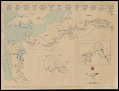
Language: EnglishRegion Depicted: BelgiumEngland
GermanyHollandNormandy, FranceMap Type: GeographicalHistorical mapsDimensions: 53 x 72 cm
Material Type: PaperHistorical Context: Top of map are listed different battles and advances of the corps ending with contact with the Soviets on April 26th and declaring V-E day on May 9, 1945. Insets: Battle of the Ardennes and the Roer-Rhine showing the Ruhr pocket. The Ardennes battle referred to as the Battle of the Bulge was a major German offensive campaign on the Western Front from December, 1944 to January 25, 1945. The Ruhr pocket was a battle of encirclement that took place in April, 1945 at the end of World War II also on the Western Front.
LC Call Number: G5831.S7 1945 U5
OCLC: 1277190073
Accession Number: OML-1945-169
Subjects: World War, 1939-1945