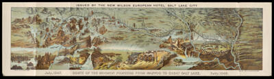
Osher Map Library Sheet Map Collection

4,458 results

Springvale, Maine looking west drawn and published by Geo. E. Norris.
Printmaker:
Publisher:
Language:
Region Depicted:
Map Type:
Dimensions: 28 x 57 cm on sheet 18 x 71 cm
Printing Process:
LC Call Number: G3734.S79 1888 N6
OCLC: 1418867842
Accession Number: OML-1888-67
Springvale, Maine looking west drawn and published by Geo. E. Norris.

Map of Munjoy Hill and the adjacent waters of Portland Harbor showing the proposed plan of improvements.
Publisher:
Surveyor:
Language:
Region Depicted:
Map Type:
Dimensions: 41 x 45 cm on sheet 48 x 54 cm
Printing Process:
LC Call Number: G3734.P8 1869 P4
OCLC: 1418965763
Accession Number: OML-1869-66
Map of Munjoy Hill and the adjacent waters of Portland Harbor showing the proposed plan of improvements.

Birds Eye View of Dexter Penobscot Co. Maine 1878.
Publisher:
Language:
Region Depicted:
Map Type:
Dimensions: 32 x 61 cm on sheet 40 x 65 cm
Printing Process:
LC Call Number: G3734.D48 1878 S7
OCLC: 1419557090
Accession Number: OML-1878-86
Birds Eye View of Dexter Penobscot Co. Maine 1878.

National Soldiers Home near Dayton, Ohio.
Printmaker:
Language:
Map Type:
Dimensions: 52 x 80 cm on sheet 61 x 86 cm
Printing Process:
LC Call Number: G4084.D2 1885 K7
OCLC: 1419559951
Accession Number: OML-1885-86
National Soldiers Home near Dayton, Ohio.

Russell's Map of Maine
Printmaker:
Publisher:
Date/Date Range Produced: 1881
Language:
Region Depicted:
Map Type:
Dimensions: 70 x 55 cm mounted on linen on sheet 81 x 61 cm
Printing Process:
LC Call Number: G3730 1881.R8
OCLC: 1419698752
Accession Number: OML-1881-102
Russell's Map of Maine

Map of Waterford Maine surveyed and drawn by Daniel Chaplin.
Printmaker:
Surveyor:
Language:
Map Type:
Dimensions: 97 x 75 cm mounted on linen on sheet 100 x 80 cm
LC Call Number: G3734.W28 1850 C4
OCLC: 1419720625
Accession Number: OML-1850-77
Map of Waterford Maine surveyed and drawn by Daniel Chaplin.

Highways and byways of Girl Scouting
Printmaker:
Publisher:
Language:
Region Depicted:
Map Type:
Dimensions: 24 x 81 cm on sheet 75 x 95 cm
Historical Context: The Girl Scouts of the United States of America was founded by Juliet Gordon Low for girls that involved activities such as camping, community service and striving to better the world around them.
LC Call Number: G3701.A5 1927 G5
OCLC: 1420372683
Accession Number: OML-1927-202
Highways and byways of Girl Scouting

Picture map of India
Publisher:
Language:
Region Depicted:
Map Type:
Dimensions: 90 x 120 cm on sheet 94 x 126 cm
LC Call Number: G7650 1946.F7
OCLC: 1420386900
Accession Number: OML-1946-152
Picture map of India

Fred Parker Estate
Surveyor:
Date/Date Range Produced: 1850
Language:
Region Depicted:
Map Type:
Dimensions: 17 x 52 cm
Printing Technique:
LC Call Number: G3734.B57 1850 D6
OCLC: 1420791114
Accession Number: OML-1850-76
Fred Parker Estate

Plan of the last division of land in the town of Windham.
Surveyor:
Language:
Region Depicted:
Map Type:
Dimensions: 38 x 45 cm
Printing Technique:
LC Call Number: G3734.W65 1802 S6
OCLC: 1420894546
Accession Number: OML-1802-21
Plan of the last division of land in the town of Windham.