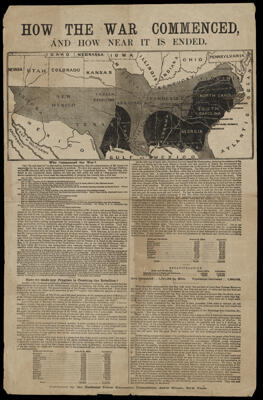
Osher Map Library Sheet Map Collection

4,458 results

Karte von Stockholm
Publisher:
Date/Date Range Produced: 1952
Language:
Region Depicted:
Map Type:
Dimensions: 41 x 62 cm
LC Call Number: G6954.S7 1952 S7
OCLC: 220290029
Accession Number: OML-1952-183
Karte von Stockholm

Gouldsboro Marsh
Surveyor:
Date/Date Range Produced: 1820
Language:
Region Depicted:
Map Type:
Dimensions: 30 x 37 cm
Printing Technique:
LC Call Number: G3734.G63 1820 D6
OCLC: 1422824776
Accession Number: OML-1820-39
Gouldsboro Marsh

Frenchman's Bay, Grindstone Point
Surveyor:
Date/Date Range Produced: 1840 - 1860
Language:
Region Depicted:
Map Type:
Dimensions: 48 x 38 cm
Printing Technique:
LC Call Number: G3734.G63 1860
OCLC: 58761
Accession Number: OML-1860-71
Frenchman's Bay, Grindstone Point

Sundry Lots in no. 14
Surveyor:
Date/Date Range Produced: 1850
Language:
Region Depicted:
Map Type:
Dimensions: 33 x 39 cm
Printing Technique:
LC Call Number: G3734.B16 1850 D6
OCLC: 1426310008
Accession Number: OML-1850-78
Sundry Lots in no. 14

Plan Sh[i] Black & Am Billings
Surveyor:
Date/Date Range Produced: 1851
Language:
Region Depicted:
Map Type:
Dimensions: 58 x 41 cm
Printing Technique:
LC Call Number: G3734.D42 1851 D6
OCLC: 1426310217
Accession Number: OML-1851-73
Plan Sh[i] Black & Am Billings

[No. 14 and 15]
Surveyor:
Language:
Region Depicted:
Map Type:
Dimensions: 38 x 31 cm
Printing Technique:
LC Call Number: G3734.B16 1850
OCLC: 1426310302
Accession Number: OML-1840-38
[No. 14 and 15]

Defense map of United States showing the mobilization of our military and economic resources prepared by C.S. Hammond & Co.
Publisher:
Date/Date Range Produced: 1942
Language:
Dimensions:  H 56 X W 81 cm
LC Call Number: G3701.S7 1941.C2
OCLC: 1126009022
Accession Number: OML-1942-229
Defense map of United States showing the mobilization of our military and economic resources prepared by C.S. Hammond & Co.

Theodore Roosevelt Spanish War Memorial Map
Printmaker:
Publisher:
Language:
Region Depicted:
Map Type:
Dimensions: 43 x 57 cm on sheet 47 x 63 cm
Material Type:
Historical Context: The United States went to war against Spain in 1898 to help free Cuba from Spanish rule. After this conflict the United States expanded its interests to other Spanish possessions such as the Philippines and Puerto Rico. It also intervened in the Boxer Rebellion in China along with an eight-nation alliance to defeat the rebellion.
LC Call Number: G4921.A5 1935 W5
OCLC: 1427975428
Accession Number: OML-1935-174
Subjects:
Theodore Roosevelt Spanish War Memorial Map

Sanitary and social chart of the Fourth Ward of the city of New-York : to accompany a report of the 4th Sanitary Inspection District, made to the Council of Hygiene of the Citizens' Association by E.R. Pulling, M.D. assisted by F.J. Randall
Publisher:
Language:
Region Depicted:
Map Type:
Dimensions: 45 x 57.5 cm on sheet 51 x 60.5 cm
Printing Process:
Material Type:
Historical Context: A map depicting the area of Lower Manhattan on public health conditions in New York City's Fourth Ward compiled by Ezra R. Pulling, M.D. as a larger study of living conditions in the city.
LC Call Number: G3804.N4:2L67 1864
OCLC: 40605209
Accession Number: OML-1865-59
Sanitary and social chart of the Fourth Ward of the city of New-York : to accompany a report of the 4th Sanitary Inspection District, made to the Council of Hygiene of the Citizens' Association by E.R. Pulling, M.D. assisted by F.J. Randall

The Rev. W. Awdry's railway map of the Island of Sodor : showing where Thomas the Tank Engine and his friends live and work.
Printmaker:
Language:
Dimensions: 54 x 85 cm on sheet ; folded to 27 x 10 cm
Material Type:
LC Call Number: G9930 1971.A9
OCLC: 316550194
Accession Number: OML-1971-210
Subjects:
The Rev. W. Awdry's railway map of the Island of Sodor : showing where Thomas the Tank Engine and his friends live and work.