Map showing Indian reservations within the limits of the United States compiled under the direction of the Hon. T.J. Morgan, Commissioner of Indian Affairs.Publisher:United States Office of Indian Affairs, Date/Date Range Produced: 1889 Language:English Region Depicted:United States Map Type:GeographicalHistorical maps Dimensions: 54 x 86 cm Historical Context: In 1830, the Indian Removal Act was signed by President Andrew Jackson. Several tribes including Chicasaw and Creeks were forced to move westward on foot. In 1838, President Martin Van Buren sent federal troops to march remaining Cherokee holdouts some 1,200 miles to Indian Territory in the Plains. The journey rampant with disease and starvation became known as the "Trail of Tears. In 1851 and 1887-89, the federal government restricted tribal members to reservations. The primary reason this time was that ranchers, settlers moving west and prospectors wanted the tribal lands. LC Call Number: G3701.G6 1889.U6 OCLC: 953192936 Accession Number: OML-1889-138
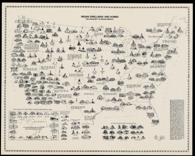
Indian dwellings and homes by William M. RieskePrintmaker:Rieske, William M. Language:English Region Depicted:United States Map Type:GeographicalHistorical maps Dimensions: 55 x 71 cm Historical Context: Originally issued by Cultural Maps of North America and published by Historic Indian Publishers in 1981. Different forms of housing structures and individual dwellings are illustrated along with text providing information such as tribal names. LC Call Number: G3701.E1 1981.R54 OCLC: 9869666 Accession Number: OML-1981-138