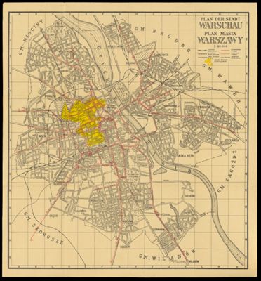
Paln der stadt Warschau - Plan miasta Warszawy
Language: GermanPolishRegion Depicted: Warsaw, PolandMap Type: GeographicalHistorical mapsDimensions: 39 x 36.5 cm on sheet 41 x 38 cm
Material Type: PaperHistorical Context: On September 1, 1939, Germany invaded Poland capturing Warsaw on October 1st, 1939. Many who resisted the invasion were either executed by the Nazi Einsatzgruppen execution squads or were sent to concentration camps as forced laborers. Although Warsaw was liberated by the Soviet Red Army in January, 1945, Poland came under Soviet rule until the fall of Communism in 1989.
LC Call Number: G6524.W3 1941 P5
OCLC: 1533965656
Accession Number: OML-1941-163
Subjects: World War, 1939-1945