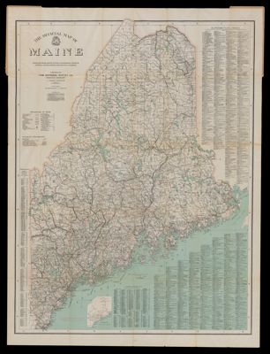
Osher Map Library Sheet Map Collection

4,635 results

Dennison/Hammond Superior Map of the United States
Publisher:
Date/Date Range Produced: 1989
Language:
Region Depicted:
Dimensions: 64 x 97 cm
Accession Number: OML-1989-136
Donor:
Dennison/Hammond Superior Map of the United States

The Official Map of Maine
Creator:
Publisher:
Date/Date Range Produced: 1918
Language:
Region Depicted:
Dimensions: 112 x 83 cm
OCLC: 57224888
Accession Number: OML-1918-40
Subjects:
The Official Map of Maine

Steel's New and Correct Chart of the Coasts of Flanders and Holland from Boulogne to the Hague
Date/Date Range Produced: 1831
Language:
Accession Number: OML-1831-34
Steel's New and Correct Chart of the Coasts of Flanders and Holland from Boulogne to the Hague

A new chart of the Cattegat and Baltic or East Sea
Creator:
Date/Date Range Produced: 1810
Language:
Accession Number: OML-1810-11
A new chart of the Cattegat and Baltic or East Sea

North America
Creator:
Date/Date Range Produced: 1880
Language:
Accession Number: OML-1880-64
North America

The World
Creator:
Date/Date Range Produced: 1992
Language:
Accession Number: OML-1992-82
The World

New and Improved Chart of the North Sea or the German Ocean
Creator:
Date/Date Range Produced: 1810
Language:
Dimensions: 83 x 135
Accession Number: OML-1810-12
New and Improved Chart of the North Sea or the German Ocean

The Fourth Armored Division
Publisher:
Date/Date Range Produced: 1945
Language:
Region Depicted:
Map Type:
Dimensions: 92 x 120 cm
Accession Number: OML-1945-35.1
Subjects:
The Fourth Armored Division

Gulf of Mexico and Caribbean Sea, including the West Indies
Publisher:
Date/Date Range Produced: 1966
Language:
Dimensions: 80 x 123
OCLC: 51176093
Accession Number: OML-1966-85
Gulf of Mexico and Caribbean Sea, including the West Indies