Osher Map Library Sheet Map Collection
4,666 results
Planetary System. Eclipse of the Sun. The Moon. The Zodiacal Light. Meteoric Shower.
Creator: Western Publishing HouseYaggy, L. W. (Levi W.)Date/Date Range Produced: 1887
Language: EnglishMap Type: Celestial chartsThematic mapsDimensions: W 90 x H 59 cm
OCLC: 431347062
Accession Number: OML-1887-37.2
See Also: Map of Africa designed especially for class work, recently compiled from the latest and most reliable sources.Map of Asia designed especially for class work, recently compiled from the latest and most reliable sources.Map of Eastern Hemisphere with four globes, showing north and south circumpolar area. Also rain-fall, winds, vegetable products, animal life, etc., in different sections of the earthMap of Europe designed especially for class work, recently compiled from the latest and most reliable sources.Map of North America designed especially for class work, recently compiled from the latest and most reliable sources.Map of South America designed especially for class work, recently compiled from the latest and most reliable sources.Map of Western Hemisphere with four globes, showing showing land and water hemispheres. Also rain-fall, winds, vegetable products, animal life, etc., in different sections of the earthThe Five Zones Showing in a Graphic Manner the Climates, Peoples, Industries & Productions of the EarthYaggy's Geographical Study: comprising physical, political, geological and astronomical geography

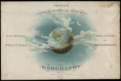
Yaggy's Geographical Study: comprising physical, political, geological and astronomical geography
Creator: Yaggy, L. W. (Levi W.)Publisher: Western Publishing CompanyDate/Date Range Produced: 1887
Language: EnglishOCLC: 431347062
Accession Number: OML-1887-37.1
See Also: Map of Africa designed especially for class work, recently compiled from the latest and most reliable sources.Map of Asia designed especially for class work, recently compiled from the latest and most reliable sources.Map of Eastern Hemisphere with four globes, showing north and south circumpolar area. Also rain-fall, winds, vegetable products, animal life, etc., in different sections of the earthMap of Europe designed especially for class work, recently compiled from the latest and most reliable sources.Map of North America designed especially for class work, recently compiled from the latest and most reliable sources.Map of South America designed especially for class work, recently compiled from the latest and most reliable sources.Map of Western Hemisphere with four globes, showing showing land and water hemispheres. Also rain-fall, winds, vegetable products, animal life, etc., in different sections of the earthPlanetary System. Eclipse of the Sun. The Moon. The Zodiacal Light. Meteoric Shower.The Five Zones Showing in a Graphic Manner the Climates, Peoples, Industries & Productions of the Earth
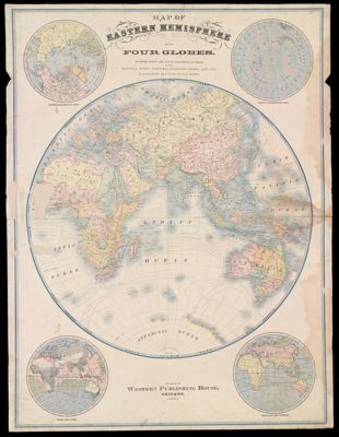
Map of Eastern Hemisphere with four globes, showing north and south circumpolar area. Also rain-fall, winds, vegetable products, animal life, etc., in different sections of the earth
Creator: Yaggy, L. W. (Levi W.)Publisher: Western Publishing CompanyDate/Date Range Produced: 1887
Language: EnglishRegion Depicted: Eastern HemisphereOCLC: 431347062
Accession Number: OML-1887-37.3
See Also: Map of Africa designed especially for class work, recently compiled from the latest and most reliable sources.Map of Asia designed especially for class work, recently compiled from the latest and most reliable sources.Map of Europe designed especially for class work, recently compiled from the latest and most reliable sources.Map of North America designed especially for class work, recently compiled from the latest and most reliable sources.Map of South America designed especially for class work, recently compiled from the latest and most reliable sources.Map of Western Hemisphere with four globes, showing showing land and water hemispheres. Also rain-fall, winds, vegetable products, animal life, etc., in different sections of the earthPlanetary System. Eclipse of the Sun. The Moon. The Zodiacal Light. Meteoric Shower.The Five Zones Showing in a Graphic Manner the Climates, Peoples, Industries & Productions of the EarthYaggy's Geographical Study: comprising physical, political, geological and astronomical geography
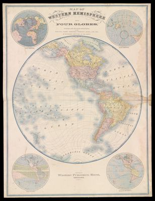
Map of Western Hemisphere with four globes, showing showing land and water hemispheres. Also rain-fall, winds, vegetable products, animal life, etc., in different sections of the earth
Creator: Yaggy, L. W. (Levi W.)Publisher: Western Publishing CompanyDate/Date Range Produced: 1887
Language: EnglishRegion Depicted: Western HemisphereOCLC: 431347062
Accession Number: OML-1887-37.4
See Also: Map of Africa designed especially for class work, recently compiled from the latest and most reliable sources.Map of Asia designed especially for class work, recently compiled from the latest and most reliable sources.Map of Eastern Hemisphere with four globes, showing north and south circumpolar area. Also rain-fall, winds, vegetable products, animal life, etc., in different sections of the earthMap of Europe designed especially for class work, recently compiled from the latest and most reliable sources.Map of North America designed especially for class work, recently compiled from the latest and most reliable sources.Map of South America designed especially for class work, recently compiled from the latest and most reliable sources.Planetary System. Eclipse of the Sun. The Moon. The Zodiacal Light. Meteoric Shower.The Five Zones Showing in a Graphic Manner the Climates, Peoples, Industries & Productions of the EarthYaggy's Geographical Study: comprising physical, political, geological and astronomical geography
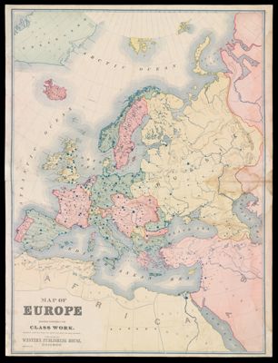
Map of Europe designed especially for class work, recently compiled from the latest and most reliable sources.
Creator: Yaggy, L. W. (Levi W.)Publisher: Western Publishing CompanyDate/Date Range Produced: 1887
Language: EnglishRegion Depicted: EuropeOCLC: 431347062
Accession Number: OML-1887-37.5
See Also: Map of Africa designed especially for class work, recently compiled from the latest and most reliable sources.Map of Asia designed especially for class work, recently compiled from the latest and most reliable sources.Map of Eastern Hemisphere with four globes, showing north and south circumpolar area. Also rain-fall, winds, vegetable products, animal life, etc., in different sections of the earthMap of North America designed especially for class work, recently compiled from the latest and most reliable sources.Map of South America designed especially for class work, recently compiled from the latest and most reliable sources.Map of Western Hemisphere with four globes, showing showing land and water hemispheres. Also rain-fall, winds, vegetable products, animal life, etc., in different sections of the earthPlanetary System. Eclipse of the Sun. The Moon. The Zodiacal Light. Meteoric Shower.The Five Zones Showing in a Graphic Manner the Climates, Peoples, Industries & Productions of the EarthYaggy's Geographical Study: comprising physical, political, geological and astronomical geography
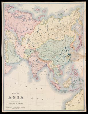
Map of Asia designed especially for class work, recently compiled from the latest and most reliable sources.
Creator: Yaggy, L. W. (Levi W.)Publisher: Western Publishing CompanyDate/Date Range Produced: 1887
Language: EnglishRegion Depicted: AsiaOCLC: 431347062
Accession Number: OML-1887-37.6
See Also: Map of Africa designed especially for class work, recently compiled from the latest and most reliable sources.Map of Eastern Hemisphere with four globes, showing north and south circumpolar area. Also rain-fall, winds, vegetable products, animal life, etc., in different sections of the earthMap of Europe designed especially for class work, recently compiled from the latest and most reliable sources.Map of North America designed especially for class work, recently compiled from the latest and most reliable sources.Map of South America designed especially for class work, recently compiled from the latest and most reliable sources.Map of Western Hemisphere with four globes, showing showing land and water hemispheres. Also rain-fall, winds, vegetable products, animal life, etc., in different sections of the earthPlanetary System. Eclipse of the Sun. The Moon. The Zodiacal Light. Meteoric Shower.The Five Zones Showing in a Graphic Manner the Climates, Peoples, Industries & Productions of the EarthYaggy's Geographical Study: comprising physical, political, geological and astronomical geography
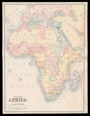
Map of Africa designed especially for class work, recently compiled from the latest and most reliable sources.
Creator: Yaggy, L. W. (Levi W.)Publisher: Western Publishing CompanyDate/Date Range Produced: 1887
Language: EnglishRegion Depicted: AfricaOCLC: 431347062
Accession Number: OML-1887-37.7
See Also: Map of Asia designed especially for class work, recently compiled from the latest and most reliable sources.Map of Eastern Hemisphere with four globes, showing north and south circumpolar area. Also rain-fall, winds, vegetable products, animal life, etc., in different sections of the earthMap of Europe designed especially for class work, recently compiled from the latest and most reliable sources.Map of North America designed especially for class work, recently compiled from the latest and most reliable sources.Map of South America designed especially for class work, recently compiled from the latest and most reliable sources.Map of Western Hemisphere with four globes, showing showing land and water hemispheres. Also rain-fall, winds, vegetable products, animal life, etc., in different sections of the earthPlanetary System. Eclipse of the Sun. The Moon. The Zodiacal Light. Meteoric Shower.The Five Zones Showing in a Graphic Manner the Climates, Peoples, Industries & Productions of the EarthYaggy's Geographical Study: comprising physical, political, geological and astronomical geography
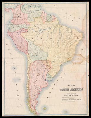
Map of South America designed especially for class work, recently compiled from the latest and most reliable sources.
Creator: Yaggy, L. W. (Levi W.)Publisher: Western Publishing HouseDate/Date Range Produced: 1887
Language: EnglishRegion Depicted: South AmericaOCLC: 431347062
Accession Number: OML-1887-37.8
See Also: Map of Africa designed especially for class work, recently compiled from the latest and most reliable sources.Map of Asia designed especially for class work, recently compiled from the latest and most reliable sources.Map of Eastern Hemisphere with four globes, showing north and south circumpolar area. Also rain-fall, winds, vegetable products, animal life, etc., in different sections of the earthMap of Europe designed especially for class work, recently compiled from the latest and most reliable sources.Map of North America designed especially for class work, recently compiled from the latest and most reliable sources.Map of Western Hemisphere with four globes, showing showing land and water hemispheres. Also rain-fall, winds, vegetable products, animal life, etc., in different sections of the earthPlanetary System. Eclipse of the Sun. The Moon. The Zodiacal Light. Meteoric Shower.The Five Zones Showing in a Graphic Manner the Climates, Peoples, Industries & Productions of the EarthYaggy's Geographical Study: comprising physical, political, geological and astronomical geography
![]()
