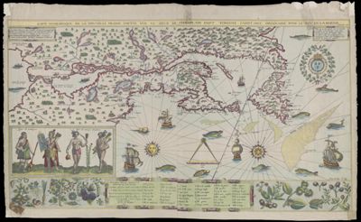
Carte geographique de la Nouvelle Franse Faitte par le Sieur de Champlain Saint Tongois Cappitaine Ordinaire pour Le Roy en la marine, faict len 1612Creator:Champlain, Samuel de, 1574-1635Piliński, Adam Date/Date Range Produced: 1612 Language:French Region Depicted:North America Map Type:GeographicalNautical charts Printing Process:Etching Material Type:Paper Historical Context: This is a redrawn copy of Samuel de Champlain's map of New France, produced in 1878. Samuel de Champlain was the first scientific cartographer of the northeastern region of North America. His detailed and remarkably accurate map is based largely on his own extensive explorations and meticulous observations of the River and Gulf of Saint Lawrence, Nova Scotia, the Bay of Fundy, and the coasts of northern New England. The only significant inaccuracies are in the renditions of Lakes Ontario and Erie, taken from Algonquian accounts and sketches. Inscriptions in the upper corners explain that the map was made to facilitate navigation "according to French compasses which vary to the northeast." The panel at the lower left center contains Champlain's own observations of the declinations of the compass at various locations in the region. LC Call Number: G5831.S12.C4 Accession Number: SM-1612-11 Donor:Smith Subjects:AnimalsIndigenous peopleNative Americans